
3. The Basin-Range Faulting Process
[For a summary placing the Basin-Range process in its wider historical context, see Meader: Geological History of our Area.]
The Basin-Range faulting process beginning about 15 MYa (mainly late Miocene Epoch) produced most of the major landscape details we see in our immediate area today. While earlier work suggested a briefer duration of the events outlined below, more recent research suggests that major faulting in our area occurred sometime between 12 and 6 MYa, raising the Catalina-Rincon Core Complex several thousand feet in elevation. See The Pirate and Martinez Faults for an initial report on these recent findings.
In our 2001 Geology Walk, Mick Meader illustrated how the contrast of Basin-and-Range developed through a process of extension of the continental crust, causing faults which made major blocks of formations drop thousands of feet (becoming "grabens"), while other blocks remained higher or even rose (becoming "horsts"). The model he shows below illustrates this, the one at left showing the land when compressed, the one at right when the land is pulled apart, breaking along various fault lines, some parts dropping and others rising.
Bob Scarborough applied this to the map (below right) of the lower part of the Basin-Range Province, his hands stretching apart to reflect an East-West direction of spreading for the entire West and Southwest region located east of the Sierra Nevada. He observed that this stretching, block-faulting process is still occurring in the further northern part of the Basin-Range Province, in British Columbia. In our area, it began at 15 MYa, is evident into northern Mexico, but has now almost ceased in our area (Click on the right-hand image for an enlargement.)


This stretching and fault-block breakage produced the large array of roughly north-south running mountain ranges, separated by parallel valleys that you can see depicted on the map at right above.
Viewed from more or less southeast-to-northwest in the diagram below, one can see that the continental crust of the Basin-Range Province has about half the thickness of the continental crust elsewhere in North America: (Click on the image to enlarge it):
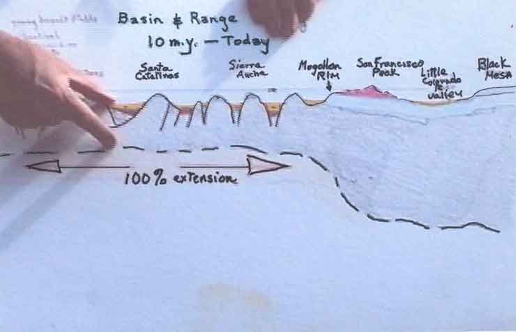
This diagram projects a roughly southeast-to-northwest cross-section of the continental crust in our area, running from the Pinacate Mountains in Mexico to the Whetstone Mountains (both are at far left, under Bob's right hand), across the Santa Catalinas, Sierra Ancha, and the Mogollon Rim to the further uplands of the Colorado Plateau at right. The double arrow shows a "100% extension" (with its associated faulting process) that took place over a period of 2-3 MY, accommodated by numerous faults, one earthquake at a time, which occurred in an east-west axis as well as the one shown southeast-northwest. The entire area remains more seismically active than in the areas of thicker continental crust, because of the hotter, shallower mantle lying beneath this part of the region.
Below, a cross-sectional diagram of the Middle San Pedro River Valley, adapted from Thomas Blakemore 2006 (see Credits), shows the underlying structure of this fault-generated basin. Not just one but a series of faults has produced a wide and deep graben structure, subsequently filled with thousands of feet of alluvial fill:

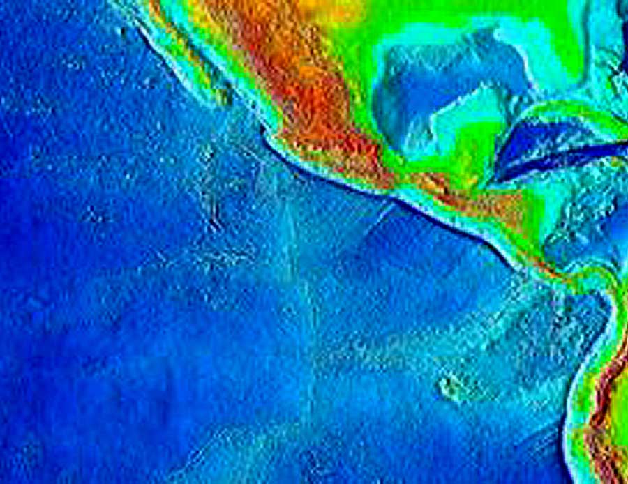
Part of the heating (and the "taffy-pull spreading" associated with it) that eventually produced the Basin-Range faulting may have been due to subduction of the East Pacific Rise -- the oceanic spreading center located to the west of North America in Cretaceous times -- its being pushed and pulled beneath the western edge of North America beginning about 30 Ma. Below find two different maps showing this spreading center. Below left, it appears in purple running from the bottom upward, leading into the Gulf of California. In the map below right, it is drawn in more subtle fashion asa jagged set of light blue lines.
 ..
..
Dickinson and others have modeled the crustal thinning described above as due to the changing angle of subduction of the Pacific Plate under the North American Plate. This material is too complex for us to examine here. At any rate, a thinning and stretching of the crust, which first caused the volcanism and detachment-faulting of the "Mid-Tertiary Orogeny" (previously discussed under (2) Metamorphic Core Complexes) later produced the extensional faulting that created our Basin-Range structures after 15 Million years ago.
Basin-Range faulting in Hot Springs Canyon is nicely shown at the Yellow Cliffs, where our outcropping of Galiuro Volcanics now sits side by side with the younger San Manuel Formation. The San Manuel formerly was deposited above this part of the Galiuro Volcanics, but dropped down with the fault somewhat more than 10 MYa:

Above, on the left, gray San Manuel Formation; on the right, Yellow Cliffs Galiuro Volcanics. Both formations, originally deposited in more horizontal layerings, were sharply tilted by Basin-Range faulting. The Teran Wash Fault, part of the more widespread faulting process of those times, runs as Mick Meader indicates above toward the left-upper-middle of the picture, to the right of the whitish pyramid which stands in the far distance, below the line of Soza Mesa; we're looking more or less northwest in this image. The whitish pyramid is part of San Manuel Formation which has fallen away from the main SM Formation to the left; the purplish hill to its right is Galiuro Volcanics. This photo was taken on the earlier Geology Walk in November 2000.)
Below, a close-up view of a piece of sharply-tilted San Manuel Formation along the Teran Wash Fault pointed to by Mick Meader in the photo above. This big chunk appears to have fallen down from the main body of San Manuel Formation in a distinctive alignment of its own.

For more images of the San Manuel Formation tilting (which followed its primary deposition from 23 to 18 Million years ago), see the geological Trip up Hot Springs Canyon, Trip up Teran Wash, and Lower Sierra Blanca Canyon Wash.
Below, a better view of the Yellow Cliffs Galiuro Volcanics themselves from a ways further downstream. We see here several layers, the lower yellowish, higher pink, higher still dark purple. In this photo, the sharp, fault-block tilt of the Formation, dipping downward away from the viewer, is more clearly evident: (Click on the image to enlarge it)
Below, a portion of the geological map of our area (compiled by Goodlin 1985 and Mark 1985 (see Credits & Bibliography), showing how the Teran Wash Fault runs through the Hot Springs Canyon from NNW to SE. (Click on the image to enlarge it):

In the image above, the yellow "Qal" means Quaternary Alluvium -- the contemporary floodplain; the beige "Tq" means "Tertiary Quiburis Formation"; the darker brown "Tsm" means Tertiary San Manuel Formation; and the pink formation is Galiuro Volcanics. The dark line running diagonally from upper-left-center, then reappearing across the canyon to the lower right, marks where the Fault can be observed on the ground, the dotted line where it is presumed to run but is buried under the more recent formations.
An aerial view of the same formations is useful here, with the red lines roughly marking the position of the Fault::

Mick Meader has provided us with the following model of this fault: (Click on the image to enlarge it):

Taking a more macroscopic perspective, note the tilt of the Galiuro Mountains as a whole when viewed from the West. This aerial photograph, below, shows the Fore-range in the foreground, while the higher, Back-range appears in a more blue, aerial cast, with its down-and-away tilt quite pronounced (Click on the image to see this detail more clearly):

The whole extent of the Galiuros Mountains forms a Fault-block Range of this kind. That several distinct episodes of faulting occurred is evident from this view below, taken from our Saguaro Juniper uplands. Here the West Range lies in the middle distance, while the higher East Range forms the background. The tilt directions of the two at this point are quite different.

See This link for a panoramic view of the Galiuros from South to north, as seen from the top of the plutonic granite Core Complex of the Pinaleno Mountains further east. (It also illustrates the lie of the Sulphur Springs Valley, another Graben structure located between the two mountains.)
Thanks to Google Earth, we can now see full Macro views of such complexes as the Galiuro Mountains. Witness this image:

In the image above, Soza Mesa is the pale buff horizontal "V" extending out toward near-middle far left, while the two white lines along the upper mid-left and lower mid-right of the image indicate the approximate position of a major fault line running through the mountains, dividing the East from the West Range. Close visual examination of the complex will show the consistent west-south-westward uptilt of both ranges. Redfield Canyon cuts across the major fault line just below the bottom end of the upper white line that marks the northern portion of the fault. Note that both Hot Springs Canyon and Redfield Canyon -- when they cut their ways across the Galiuro ranges during the capture of the San Pedro Valley watershed by the Gila River 2 or 3 million years ago -- both left hanging Quiburis Terraces, remnants of earlier large-scale erosion some 7.5 to 5 million years ago, which followed the Basin-Range tilting episodes that so drastically moved these mountains but preceded the drainage capture.
For more images and maps describing the Galiuro Mountains, see The Galiuros.
Below, Mick Meader has provided a series of models depicting the process of Basin-Range erosion.


Next
Previous