
4. More Recent Patterns: Closed Drainages, Capture by Gila River
[In the following discussion, you may want to refer to an authoritative geological time scale; to see one adapted from the work of the University of California Berkeley Museum of Paleontology (cited in Credits & Bibliography) click on that link.]
The Upper Miocene Epoch -- 7 to 5 MYa -- was the time of the deposition of the Quiburis Formation. At that time the San Pedro Valley was a pair of closed basins (see the map below), divided by a bedrock high point just south of our Saguaro Juniper area. The St. David Basin to the south where the city of Benson is today held a large lake into which reddish, mostly clay sediments were deposited (the "pink terraces" now visible around the town, see San Pedro River & Land Forms). The northern closed basin shown on the map below also held a lake the deepest portion of which was north of Mammoth, and which did not extend south as far as Cascabel. In our area the sediments were deposited at the lower ends of alluvial fans spreading into the valley from the mountains on either side, notably at Soza Mesa (see the banner photo above).

As the Schematic Diagram (above -- thanks again to Mick Meader!) suggests, the Quiburis Formation in our area is mostly from "alluvial fan and braidplain deposits." The illustration below of fairly typical Quiburis deposits at a lower part of Soza Mesa, in lower Hot Springs Canyon, shows a fairly typical interlayering of gravels and siltbeds:

What you see here are layers of gravel (some with quite large, river-rounded boulders, many of which are basaltic) interspersed with layers of reddish clay. This pattern (alternating aggrading and degrading sediments) appears to be widespread over Soza Mesa. This Quiburis clay, incidently, becomes extremely sticky when wet. It also bonds the formation more strongly than its sedimentary predecessor the San Manuel Formation, producing more vertical-cliff erosion patterns than the older Formation (as seen for example in Hot Springs Canyon).
Quiburis terraces are especially noteworthy near Mileposts 15-16, where they hang out above the San Pedro River Valley floodplain. See this view of them below:

The slope of these terraces indicates the shape of the valley along this area prior to its capture by the Gila drainage. Presumably this slope extended all the way across to the point where it met its counterpart bajadas extending from the eastern side.
Upstream, to the South, the St. David Basin Lakebeds apparently extend well north of the Benson Narrows (see the "Drainage Divide" marked on the schematic map above), as far downstream anyway as the area around what is today the Three Links Ranch. Witness these pink, apparently lakebed deposits in the Quiburis-period terraces above the current riverbed at the latter location: (Click on the image for a closer view)
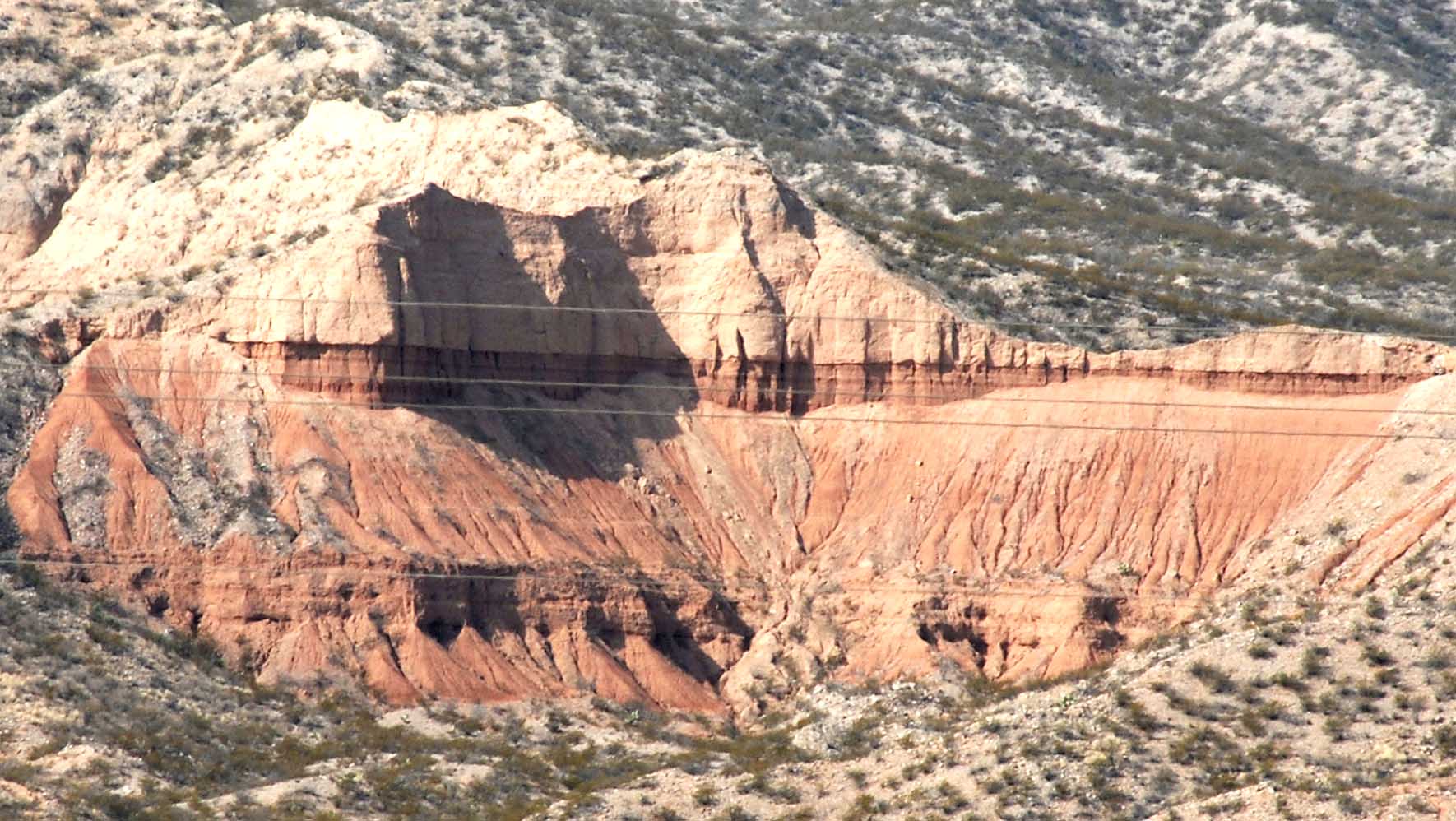
[Note that the light-colored horizontal lines clearly visible in the closeup are power lines running between the viewer and the cliff face.]
Then, during the Pliocene Epoch beginning about 5 MYa, a regional drainage network began to form that gradually linked these closed basins with drainages to the northwest, culminating with the capture of the San Pedro Valley by the Gila River system several million years ago, and resulting in the erosion of Quiburis sediments and the unloading of the basins. This erosion produced (for example) our Hot Springs Canyon, while, in the image below, the upper part of Soza Mesa shows the original lie of the alluvial fans that formerly filled the San Pedro River valley all the way across (and are now only remnant Quiburis terraces which look down at today's floodplain).

Here (above), viewed from the somewhat higher peak of Sierra Blanca (and looking northward toward Kielberg Peak), the surface of Soza Mesa can be seen as a strip of brownish green (mostly creosote bush vegetation) running in an almost straight, near-horizontal line along the far side of Hot Springs Canyon (the seemingly sharper slope in this image is due to videocam tilt). Further west, the Mesa decays into a series of fragmented, fingerlike ridges dropping down toward today's valley floor, as this Topo Map shows::
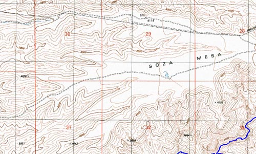
(The perennial water of Hot Springs Canyon is shown in blue at the lower right-hand corner of this map.)
Even as a remnant, upper Soza Mesa is a strikingly linear formation, especially when viewed at nearly eyelevel from the uplands across Hot Springs Canyon to the southeast:

This low-angle aerial view, below, shows how the down-cutting of Hot Springs Canyon (through layers of Quiburis Formation once covering them as part of the ancestral Soza Mesa) ultimately exposed older formations underlying it: (again, the surface of Soza Mesa is the almost horizontal straight line across the middle portion of the photo)

For more views of Soza Mesa Quiburis Formations, see that link in the Landscapes page: Soza Mesa.
Perhaps an even more remarkable image of the Quiburis terraces of our area is one taken from afar, near Milepost 10 along the Cascabel Road, looking North::

Here (above), against the backdrop of the Galiuro Mountains, Soza Mesa is the distant straight line running across the central-left part of the photograph, ending on its upstream side just right of center where the rising ridges of Sierra Blanca (the dark form slightly to the right of mid-photograph) obscure it. Toward the left it tapers down toward the river, but even more distant Quiburis-period terraces, also looking like straight lines from this viewpoint, obscure this dropoff. To the right of Sierra Blanca, other Quiburis-era terraces are visible.
Remnant Quiburis terraces may be seen at a number of locations along the San Pedro valley in our area. For example, note the photograph on the Sierra Blanca page, the one dated January 16, 2000. This shows a river terrace in the mid-distance, which frames the more distant mountain rising behind it. This terrace also shows the level of the valley before the capture of the drainage by the Gila River. (For more images of the San Pedro Valley and its hanging terraces, see San Pedro land forms etc., which includes some of the old-lake terraces from the "Quiburis Basin", further downstream.)
Capture of this entire region by the Gila River (producing its new tributary, the San Pedro River) continues to degrade the elevations of all the landforms in our area.
For an outline summary placing the Quiburis Formation and its erosion process in its wider historical context, see Meader: Geological History of our Area.
Previous
Next
Return to Geology main page