
5. Older Patterns: Willow Canyon, HSC Thrust Faulting during Cretaceous Times
[For a summary placing the Hot Springs Canyon Thrust Fault process in its wider historical context, see Meader: Geological History of our Area. ]
This final page of the Geology Walk concerns the most remote in time that we try to deal with, and is in some ways the most difficult to understand. We will develop the page more fully in the future, but for now this brief account must suffice. Much of the regional-context detail that fits here is now located at the Geology of Hot Springs Canyon, so for discussions of Thrust-Faulting see the lower parts of that page.
Early Cretaceous Willow Canyon deposits:
The diagram map below shows inferred tectonic setting with an outline map of Arizona imposed. The Mogollon Highlands were in place, while southeastern Arizona was a depositional basin, referred to as the "Bisbee Basin".

The Willow Canyon Formation (the very upper end of the portion labelled "Bisbee Basin") developed around 120 MYa, in a rift basin linked to the southeast with the Gulf of Mexico (on the lower right in the diagram). These sediments were deposited by rivers flowing down this rift, into the Basin. Toward the north-northwest and towards the sides of the basin were alluvial fans and braid plains similar to those we see in the Quiburis and San Manuel formations.
Much later, the Laramide Orogeny, or mountain-building, began about 80 MYa and continued until about 40 MYa, associated with an increasing westward rate of motion of North America over the Pacific plate, which greatly compressed the crust, forming the Rocky Mountains of Colorado and Wyoming, and also producing the volcanism of the Muleshoe Volcanics in our area at about the same time the Cascabel Formation was being laid down (about 70-66 MYa). The Laramide thrust-faulting which pushed the Willow Canyon formations from the southwest to the northeast and into our area occurred sometime after 66 MYa, since the thrusting overrides the younger Cascabel Formation.( Muleshoe Volcanics lie outside the area of Saguaro-Juniper, running from a short ways west of Hooker's Hot Springs in the SE in a roughly NW direction to more than a mile north of Hot Springs Canyon, where the Canyon is running from east to west in its northernmost reach.)
Our best local view of the impact of this thrust-faulting may be seen in upper Hot Springs Canyon at the isoclinal fold: (Click on the image to enlarge it)

In this case, the Willow Canyon Formation over-thrusting was so strong that it folded over itself at this extreme point. Remarkably, the fold was exposed by the much-later erosion of Hot Springs Canyon.
A broader sense of the forces involved in this thrust-faulting may be gained from viewing a geological map of the relations between the Willow Canyon and the Cascabel Formations in the landscapes around Hot Springs Canyon:
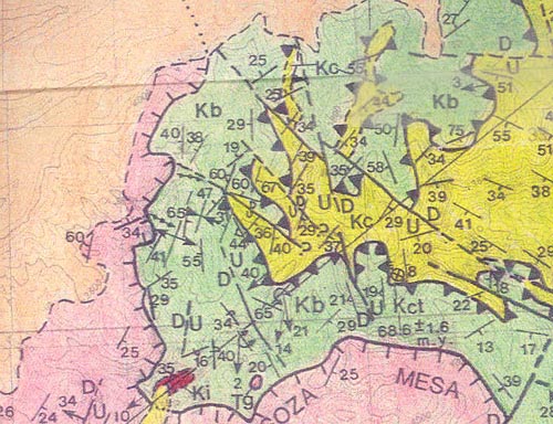
In this map, the lie of Hot Springs Canyon (which runs roughly from upper right to lower left) may be seen in the yellow finger (= Quaternary alluvium) with the red tip (= Cretaceous Intrusive formation, "Ki")) located at the bottom toward the left, marking the place of the Canyon's boundary with the Soza Mesa Fault and the Galiuro Volcanics (shown in pink). The Willow Canyon Formation is green ("Kb") and the Cascabel is Yellow ("Kc"). The shape of the Hot Springs Thrust Fault here (fault thrusting was directed here from lower left -- SW -- toward upper right -- NE) is very tortured indeed. (See these Links to Geology of Hot Springs Canyon and Geology of Pool Wash for more details and some examples.)
Previous
Return to Geology Home Page