Sonoran Desert: The Arizona Uplands
Main sources: Shreve, Forrest, 1951, Vegetation of the Sonoran Desert, Washington, D.C.: Carnegie Institute of Washington Publication 591; Phillips, Steven & Patricia Comus, eds., 2000, A Natural History of the Sonoran Desert, Tucson: Arizona-Sonora Desert Museum Press; Kearny, Thomas & Robert Peebles, et al., 1960, Arizona Flora. Berkeley: University of California Press; Hastings, James & Raymond Turner, 1965, The Changing Mile: An Ecological Study of Vegetation Change with Time in the Lower Mile of an Arid and Semiarid Region. University of Arizona Press; Brown, David, ed., 1994, Biotic Communities: Southwestern United States and Northwestern Mexico, Salt Lake City: University of Utah Press. Some relevant mapping of plant distributions may be found in Zimmerman, Robert, 1969, Plant Ecology of an Arid Basin Tres Alamos-Redington Area Southeastern Arizona, Geological Survey Professional Paper 485-D, Washington, D.C.; For more useful descriptions of many of the plants referred to below, see fs.fed.us/database/feis. "Feis" refers to "Fire Effects Information System", which provides a database containing descriptions of almost 900 plant species, about 100 animal species, and 16 Kuchler plant communities found in North America. While these descriptions focus on the plant's relationship with fire, background descriptions and full bibliographies are also provided. A useful source for images is the Natural Resources Conservation Service Plants Database; see plants.usda.gov.
Rather than a 'desert', the Arizona Uplands are considered by some to be better described as "Thornscrub" -- characterized by "an irregularly layered overstory between 2m and 8m in height," "typically composed of spinose, microphyllous, and succulent plant life-forms" (Brown, ed., cited above, p. 100). Raymond Turner, for example (op.cit., p. 200), characterizes the Arizona Uplands as "Truly spectacular", "the best watered and least desert-like desertscrub in North America", whose vegetation appears as a "low woodland of leguminous trees with intervening spaces held by one to several open layers of shrubs and perennial succulents." Pioneer plant ecologist Forrest Shreve called it a "stem succulent desert", referring to the prominent role played by Saguaro, cholla, and other cacti in the biome.
One reason for this richness is the mildness of the Arizona Uplands winters, another its relatively high amounts of winter rainfall. For our particular area, for example, in Cascabel at Harold Elliott's Weatherstation, the proportion of winter to summer rainfall during the past 20 years has been almost exactly 1:1, while less rich subdivisions and other North American deserts have lower proportions of winter rainfall. (Relative rates of evapotranspiration, as well as rates of rainfall, are relevant aspects of this factor.)
1) Shreve's Maps and the boundaries of the Arizona Uplands near Cascabel
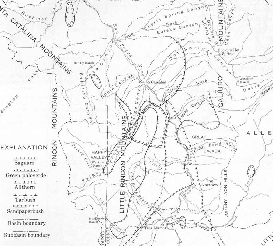
The southeastern extent of the Arizona Uplands is problematic for our area. The map below, adapted from Shreve 1951 (above, facing p. 2), shows the eastern boundaries of the Sonoran Desert in the general vicinity of Tucson and Safford, as Shreve and his collaborators defined it through their travels in the area as marked with dark dashes. Their movements in relation to the San Pedro River suggest that they left the rivervalley in its southern portion somewhere near Cascabel. The approximate locations of Redington and Cascabel along the San Pedro River have been added to this image. (All of the area shown within the dotted boundary is part of the Arizona Uplands division of the Sonoran Desert according to Shreve's mappings.)

Forrest Shreve definitely marked his northeastern boundaries of the Arizona Uplands as coinciding with the distribution of the Saguaro cactus (the open circles in the map below show his marking of Saguaro locations):

Shreve made this association quite clear at several points in his text, for example, "The range of Carnegiea [the Saguaro] coincides closely with the boundary of the Sonoran Desert from the Colorado River east and south to the valley of the Rio Sonora."(p. 141) However, applying that standard today, we would more appropriately extend the boundary of Sonoran Desert (Arizona Uplands Division) along the San Pedro a considerable distance farther south, since Saguaros are found in some numbers as far south as the south-facing flanks of Pool Wash and some of them are quite old (well over 100 years).
For example, see this image from January of 2003 of the south-facing slopes of lower Hot Springs Canyon, near the canyon's confluence with the San Pedro where the location of Cascabel is typically marked:
The furthest south we see them along the Cascabel Road in the twenty-first century is around Cascabel Road Milepost 17 -- just south of Kelsey Canyon Wash, where a lone outlier probably 100 years old (with at least two arms, at far right central in the left-hand photo below) stands in the foothills east of the river: (closeup on right) (Click here for map reference to the wash locations mentioned in this immediate area.)
 zoom image:
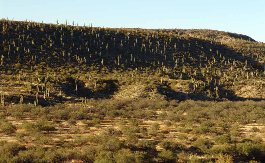
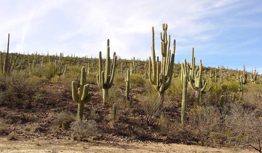
Probably other outliers can be found in this area. Near the center of Cascabel, near Milepost 23 along the south-facing edges of Hot Springs Canyon just upstream from its confluence with the river (roughly 15 miles southeast of Redington as the crow flies), there is a veritable forest of old Saguaros, interspersed with the Palo Verde trees also regarded as characteristic vegetation of the Arizona Uplands. Below, two views of this concentration, both looking north cross-Canyon. At left, the view is from the opposite terrace, at right, from the south side of the Wash. (Click on each image to enlarge it.)
 ....
....
Our Saguaro Juniper lands near this location (below 4,000') show similarly great abundance of Saguaro (and Palo Verde) growth in a number of places (see our discussions of Saguaros and Palo Verdes).
Shreve's fieldwork on the Sonoran Desert was done in the early 1930s, so some 70 years have intervened. Since his map shows Hot Springs Canyon lying about 8 miles outside the Arizona Uplands, this would imply that most of the Saguaros we now see on these slopes must have been too small to be visible to them, and would also indicate extensive recent colonization of Saguaros in an upstream direction since the time of his work. This would fit with Hastings and Turner's 1969 view that Arizona Uplands plants have been migrating upward in elevation throughout the area, due to "drier, warmer conditions at all elevations" (Hastings and Turner 1969 pp. 270, 282). But clearly the Saguaro distributional boundary must have been somewhat south of Cascabel when Shreve's survey was conducted. A large number of the Saguaros visible in these images above are clearly much more than 100 years old, and must have been visible to some extent in the 1930s. Another relevant source is Zimmerman 1969 (cited above), whose map of Saguaro distribution shows a pattern of distribution reaching as far south as The Narrows (on the west side of the River), and coinciding with our own observations; see Zimmerman map for this information.
In any case, since Saguaros are found in their greatest abundance in The Arizona Uplands division of the Sonoran Desert, it seems clear that Shreve's Arizona Uplands boundary near Redington might appropriately be redrawn to extend into our area. Note, for example, The Nature Conservancy's map of this boundary area, which appears to contain a correction along these lines. On the other hand, some other more recent classifications of southwestern deserts exclude our area entirely from "Sonoran Desert" status, and some characterize Cascabel and the Lower Hot Springs Canyon as "Chihuahuan Desert Scrub". We discuss these issues further in our page on The Chihuahuan Desert, whose centrality in our particular area is definitely problematic, judging by the diversity of classification schemes we have encountered as applied to our part of the valley.
2) The Climate History of the Arizona Uplands
For details, see these links:
SE AZ Climate History and the Vegetation Communities of the A-7 Ranch
1850s-1960s Sonoran Desert vegetation changes (Hastings & Turner 1965).
3) Shreve's characterization of the Vegetation of the Arizona Uplands
[Note: in the discussion which follows, go to the underlined links for images and plant details.]
As Shreve saw it, the Arizona Uplands lay mainly in Arizona, where it is flanked on the north and east side by a broken series of mountains (in our area, the Galiuros, including their geological extensions, the Johnny Lyon Hills east of the River). He defined Creosotebush, Foothills Palo Verde, Velvet Mesquite, Saguaro, Barrel Cactus, Ocotillo, and "12 or 15 species of [Cholla] and [Prickly Pear]" (p. 42) as plants of major importance to this part of the Sonoran Desert, warranting its designations as "Palo Verde-Prickly Pear Desert", or "Stem-succulent" Desert (pp. 42-3, the latter label alluding to Saguaros, Barrel Cactus and other woody-stemmed cacti).
Shreve characterized the Arizona Uplands vegetation as an "open stand" of tiny-leaved shrubs and trees with -- in some areas -- a strong admixture of succulents and other types of plants. Within areas, vegetation varies:
1) ON THE PLAINS AND LOWER BAJADAS:
soils are usually a loam or sandy loam including much coarse gravel, with surfaces often underlain by calcareous hardpan (caliche). Creosotebush, Acacias, and mesquites are often found together, all low in height away from streamways. Small shrubs are also common, including varieties of bursage. Grasses are few except in poorly drained areas of heavy soil (where Hilaria may be found), and under creosote bush where Bush Muhly is often sheltered.
2) ON THE UPPER BAJADAS
-- the pediments surrounding mountains --
soils derived from a single mountain range (mainly of igneous origin), resulting in course soils often cemented on hardpan and including much coarse sand producing rapid lateral migration of streamways. This area produces the most abundant and dense vegetation in any part of the Sonoran Desert north of the International boundary -- many large and tall perennials -- Saguaros, creosote bush, foothills paloverde, Ocotillo, mesquite et al are found on nearly every square kilometer of the area.
Shreve presented the following lists of perennials as characteristic of these upper bajadas (p.64):
A) Perennials more than 1 meter in height:
Foothills Paloverde (Cercidium microphyllum), Creosotebush (Larrea tridentata), Whitethorn Acacia (Acacia constricta), Ocotillo (Fouquieria splendens), Velvet Mesquite (Prosopis velutina), Staghorn Cholla (Opuntia versicolor), Ironwood (Olneya tesota), Opuntia engelmannii, Catclaw Acacia (Acacia greggii), Cholla (Opuntia fulgida), Desert Hackberry (Celtis pallida), Wolfberry or Desert-thorn (Lycium berlandieri & Fremontii), Barrel Cactus (Ferocactus wislizenii), Jojoba (Simondsia chinensis), Mormon Tea (Ephedra trifurca), Opuntia spinosior, Graythorn(Condalia lycioides), Adelia or Wild-olive (Forestiera neomexicana), and Squaw-bush (Condalia spathulata).
B) Smaller perennials accompanying (A):
Triangle-leaf Bursage (Franseria deltoidea), Brittlebush (Encelia farinosa), Fairy-duster (Calliandra eriophylla), Christmas cactus (Opuntia leptocaulis), Desert Zinnia (Zinnia grandiflora), Opuntia phaeacantha), Range Ratany (Krameria glandulosa), Coldenia canescens, Menodora scabra, Psilostrophe sparsiflora, Brickellia coulteri, Mariola (Parthenium incanum), Muhlenbergia porteri, Globe-Mallow (Sphaeralcea grossulariaefolia), Sangre-de-Christo (Jatropha cardiophylla), Trixis californica, Nose-burn (Tragia ramosa), Pincushion Mammilaria (Mammilaria microsperma), Hibiscus (Rose-mallow) (Hibiscus denudatus & coulteri), Ayenia microphylla, Dalea parryi, Indian-mallow (Abutilon incanum), Milk-wort (Polygala macradenia), Porophyllum gracile, cockroach-plant (Haplophyton crooksii).
3) In the Streamways:
The banks and margins of streamways in the Arizona Uplands show differences in vegetation from other surfaces -- sometimes only in density and size of the common species (above), but sometimes in the presence of distinctive species. Usually both are present. As deposits of sand deepen, vegetation becomes denser and taller. Blue Palo Verde (Cercidium floridum) tends to be found mostly in such places, where it grows taller than its Foothills relative. How different the vegetation is depends on the character of storm floods and the distance from headwaters. Close to the parent mountain, streamways are full of boulders, whereas further downstream where the gradient is gradual, the floodplain has been built up by wide and slower moving floods, and soil is mostly a fine alluvial clay.
A) Boulder floodplains
have a rich supply of water, and often include a mingling of desert trees with those of higher elevations. Various species of Oak (Quercus spp) -- not evident on our lands -- and Juniper -- which we do have -- may mingle with the desert riparian Cottonwoods (Populus fremontii), Goodding Willow (Salix gooddingi), Arizona Ash (Fraxinus velutina), Arizona Walnut (Juglans major), Arizona Sycamore (Platanus wrightii), Mexican Elder (Sambucus mexicana), and Netleaf Hackberry (Celtis reticulata), all of which are found along with Velvet Mesquite (Prosopis velutina).
B) Downstream Alluvial Floodplains
Typically a mile or so downstream from the mountain base there is a great reduction of the number of trees and shrubs, with Mesquite most common (sometimes in almost pure stands), with Cottonwoods and Willows where water supply remains favorable. Where the floodplains are sandy, the dominant plants become Burro Bush (Hymenoclea monogyra) and Desert Broom (Baccharis sarothroides). Desert Willow (Chilopsis linearis) is often found with these two on the sandy floodplains, and all three serve to catch silt and reduce erosion. Wild Rhubarb (Rumex hymenosepalus) and Bursage (Franseria ambrosioides) are also associated with these.