Colorado Plateau: Capitol Reef Focus

This south-to-north cross-section of the Colorado Plateau, from the Grand Canyon on the south to Bryce Canyon in the North, provides an important reminder of what makes the Plateau geologically different from the zones that flank it to the west-and-south (the Basin-Range Province) and to the east-and-north (the Rocky Mountains): its generally flat (and sedimentary-deposited) structure, albeit incised by deep canyons and punctuated here and there by intruding complexes of igneous origin. (Thanks to Ron Redfern, see the bibliography at the end of this report.)
[Note to the reader: I briefly explain reasons for my evidently-perennial obsession with the Colorado Plateau in this link: Why have a CP Obsession, anyway? It contains among other things a fascinating video of driving narrow Utah Highway 12 at speed with precipices hanging at both sides.]
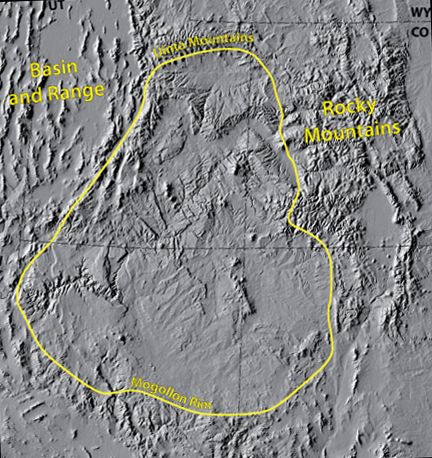
This relief map at left delineating the overall Plateau gives some additional sense of the contrast among these three major Provinces, though the Basin-and-Range difference (far left) is far more widespread than the small area shown here, including a sweep around to the south through southern Arizona and deep into Mexico as well as extension northwestward as far as Oregon. This Basin-Range Province results from massive extensional forces pulling the region apart. dating from some 15 million years ago, while the Rocky Mountain Province to the east was the product of a series of compressional forces culminating in the "Laramide Orogeny" that began some 70+ million years ago and lasted until 40 Mya or so. In between these two very different geological provinces lies the much flatter one called the Colorado Plateau, one of whose north-south cross-sections you see reproduced at the top of this page. While the contrast among the three is as great as their respective appearances suggest, the forces underlying the other two have definitely affected the Plateau, as we shall see.
This map comes from the website of Anne E. Egger at the Stanford University School of Earth Sciences, who is working up a website page on the Colorado Plateau. Here is a link to that site:
Note the dimple in the middle part of the eastern boundary demarcated for the Plateau. Donald Barrs, a retired geologist who spent most of his career studying the four-corners area, suggests that the San Juan Mountains (excluded from the Plateau as the external portion to the dimple on the grounds of their Rockies-like complexity) are probably better grasped as part of the Plateau itself.
Professor Barrs (whose 2002 book, A Traveler's Guide to theGeology of the Colorado Plateau, University of Utah Press, I use as one of my guides here, though we lacked the wit to have had it during our actual trip) argues that much of the distinctiveness of this grand topographical feature lies deep in its history, that a set of "major fracture zones in the very ancient Precambrian basement (rocks that originated more than 550 million years ago) control the location and orientation of the various major geologic features". (p. 2; emphasis provided.)
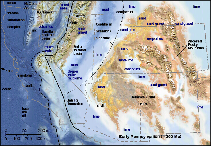
These major fracture zones, composed mainly of what geologists call "strike-slip" faults, have played recurring and pivotal roles in the evolution of the structure. Barrs suggests that the "Cordilleran Hingeline" (or Wasatch Line), the boundary running NE-SW along the western edge of the Plateau, may mark the late Precambrian western edge of the North American continent, with many faults occurring along this line throughout its history as more and more terranes were added to its edges. The reconstruction at left (click on the image to enlarge it) shows this "Hingeline" as western edge during the Pennsylvanian Period of the Paleozoic (310 Mya), when continent-formation was underway further west in somewhat separate development. (Thanks to Ronald Blakely et al at Paleogeography of the Southwest for the map image.)
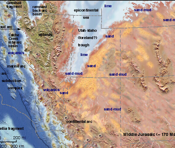
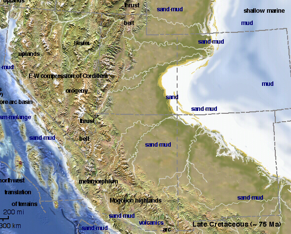
On the right-hand side of the image you can see that "Ancestral Rocky Mountains" have arisen by the time of the Pennsylvanian Period, their compressional structure already differentiating them from what will become the Plateau. So between the two other Provinces, the Plateau has maintained considerable long-term independence, under conditions fostering its long history of relative flatness. We will not discuss the basis of this flatness in great detail here, having previously provided our 2009 travelogue of the Grand Canyon-to-Zion-to-Bryce Canyons report, but something should be said here as a reminder. In that travel report,, we observed how the Grand Canyon structure directly proves that this plateau was a flat, low-lying plain which rose and fell periodically, and was inundated repeatedly by seas (which also fell and rose), as the sediments that now form these many layers were deposited during the Paleozoic Era (the end of which marks the end of the time-frame provided at the Grand Canyon itself). But this flatness continued into later times than the Paleozoic; two more map reconstructions provided by Blakely and his fellow geologists illustrate this point for the Mesozoic Era: below left, the Plateau during the Middle Jurassic Period (170 Mya); below right, during the Late Cretaceous (75 Mya): (click on each image to enlarge it). The facts are that most of the Colorado Plateau remained quite flat (and near sea-level) for nearly five hundred million years.
 ..
..
So our flat, sedimentary-deposited series cross-sectioned at the top of the page poses a major question: how is it that travelers over this country today now negotiate altitudes of five to seven thousand feet, and even higher, still riding (sometimes) on these ancient sea-floors and floodplains?
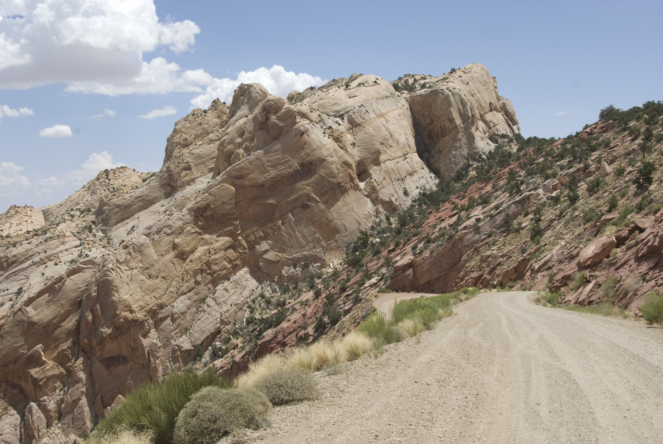
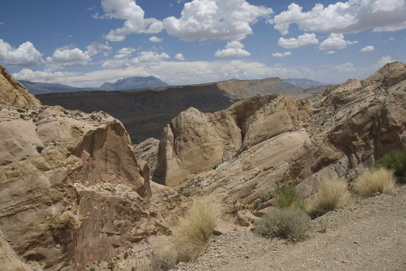
And second, if the Colorado Plateau is so sharply distinguished from its neighbors by its definitive "flatness", how do we explain experiences like these provided below to the travelers whose jaws drop when they see them (as we did on our trip this past July 19 when we drove down the last miles of the Burr Trail east of Boulder, Utah, witnessing these two huge examples of non-flatness): (click on each image to enlarge it)
 ..
..
Or take the perspective of the satellite camera, which (courtesy of Google Earth in 2009), gives us this image below of the Cockscomb, a major feature of the Colorado Plateau in south-central Utah (you can see a dirt roadway threading its way between the cliffs right down the north-south line of the picture):

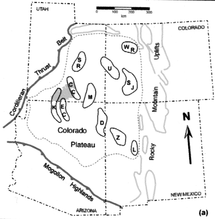
In her analysis of Cockscomb geology (see that link for discussion of the area illustrated by the form shown just above), Professor Sarah Tindall presents two diagrams of the Plateau contrasting two sequential patterns in a manner similar to that of Professor Barrs. Below left, she shows the situation of compression produced during Late Mesozoic to early Cenozoic times; below right, the much later time of extensions both to the west (Basin-Range) and east (the Rio Grande Rift):
 ..
.. 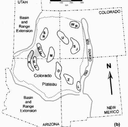
In both time periods forces external to the Plateau were exerting pressures on it, and both images include elongated, lettered circles that indicate an array of uplifts within the Plateau, emerging mainly in the late Mesozoic but persisting (with erosion) into the present time. These uplifts are accompanied by contiguous basins (some only evident indirectly, by drilling and seismic testing, because erosions from the uplifts have filled them in or because they have been intruded by volcanic forms). In his Traveler's Guide, Professor Barrs argues that both uplifts and basins on the Colorado Plateau, which have introduced distinctive regions of unevenness in this world of the flat, have been controlled largely by the ancient and deep Fracture Zones which underly the continent in this region, and which have continued intermittently active since Precambrian times [Fig. 2, p. 3]:
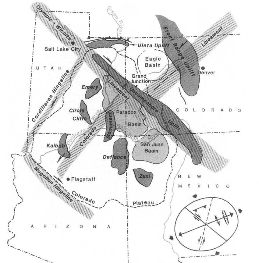
He (and numerous others) provide array diagrams of this kind, some showing much more complex (but also diagonally crosscutting) lines of faulting across the Plateau. I gather the point is: while major peripheral events (Laramide compression, Miocene Orogeny, later Basin-Range faulting, et al) have had strong causal connections with these processes, older, underlying "basement" structures have come into play directing outcomes at different times ever since Precambrian times. (Note, for example, how the Colorado River parallels an ancient fracture which has been given a suggestive name.)
Having observed this, we must bear in mind the dual questions of when and how the uplifts-basins warpings occurred, and when and how the much more general uplift of the entire region as a great block occurred.
A culminating map showing uplifts and basins of the eastern Plateau, drawn again from Barrs' book (Fig. 10, p. 20), provides a basis for us to organize descriptions of our trip:
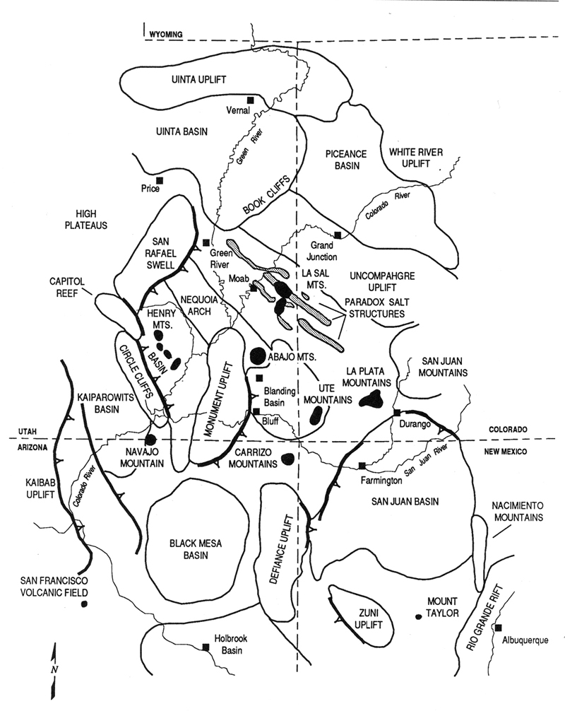
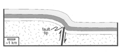
Note in the map above, first, the heavy, barbed lines, which show "the down-thrown side of the large monoclines that form the margins of the major uplifts." A monocline is formed "where flat-lying strata are draped across deep-seated faults" in a half-fold, looking like "a rug draped over a stair step". (p. 14) This is a very frequent structure in our area, with many layers of sedimentary formations distorted in this way. [The image at left is drawn from Tindall) What seems to have happened is that these basement faults, creating sharp uplifts undernearth but hidden under the blankets of overlying sedimentary rocks, produced strong monoclines on the faulted side of the uplift, while beyond this point the uplift structure sloped off more gradually as a flank.
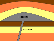
Second, note the black circles and blobs on Barrs' map above [where towns are indicated by black squares]. These represent laccoliths, igneous intrusions into sedimentary structures which dome the overlying rocks (which typically as seen today are considerably eroded away), possess flat floors where they spread out over a sedimentary level and a dikelike feeder beneath the thickest point (illustrated in the image at left, drawn from Wikipedia). These are very different from erupting volcanoes, as their bodies of magma rise slowly, are hidden within the sedimentary cover and deform it, slowly cooling into crystalline rock (granite being the typical-form), mushroom-like bodies only later exposed on the surface when the sedimentary overlay has been removed by erosion. Laccoliths are a characteristic feature of the Colorado Plateau, and Barrs observes that some of them are Cretaceous in age though most date to mid-Tertiary Orogeny times. Several attain enough altitude that they were glaciated during the Pleistocene. We will see a number of these on our journey.
Barrs' map above shows major features we encounter on our itinerary: from Blanding Basin (the town of Blanding where we stayed is noted by a black square within the Basin), we encounter first the Monument Uplift, then the Henry Basin, enroute to the Reef. I recommend that you readers also continue via that route.
Part Two: From Blanding to Capitol Reef
Part Three: Capitol Reef & Vicinity; Boulder Mountain, Burr Trail, Circle Cliffs, Waterpocket Fold