![]() ..
..![]()
July 12, 2009: to Zion and Bryce
Below, I attach a larger version of Ron Redfern's map showing a South/North crosscut of the geological continuity between these National Parks, with Grand Canyon at far left and Bryce at far right. Click on the image to obtain a larger view, which includes details of Formation sequences. This smaller image is very hard to read.
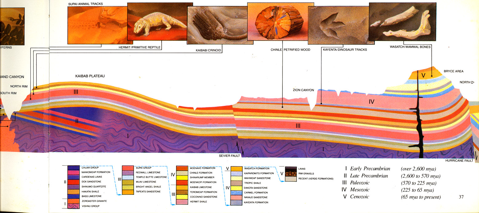
We must initially point out two major differences in geology between the Grand Canyon and Bryce. First, The Colorado Plateau up-swelling you see on the left occurred both during and after the Laramide Revolution, a long-term event (maybe 100-60 million years ago and also later) which COMPRESSED the earth's crust, forcing the bubble-like rise forming the Kaibab Plateau, through which the Grand Canyon (much more recently) cut. This cutting was part of a much more recent uplifting of the entire plateau, beginning only some 5 million years ago.
This is why the later geological strata you see to the north (IV and V on the right-hand northern side), initially also present much much of the southern area, were eroded away from this part of the plateau.
The region toward Bryce Canyon, on the other hand, while also affected by these earlier processes, was later transformed by the Basin-Range events from 15-12 million years ago. These were EXTENSIONAL processes, which caused block faulting like that we see in southern Arizona, so events in that portion of the Plateau produced some distinctive forms, which will be examined further below, and in later travels.
Second, as you go northward (toward the right), more recent geological strata are sequentially exposed, while those we have seen in the Grand Canyon are (at Zion and Bryce) concealed beneath these later ones. The Grand Canyon rim (with its Kaibab Formation) is the first "step" in what geologists call the "GRAND STAIRCASE" of this area: five tilted, southward facing escarpments, which were produced as these overlying layers were retrogressively stripped off by erosion. In the diagram above, the second step, the Moenkopi Formation, is visible as the thick crimson-bright red line above the Kaibab at left center in the image, where two river-cuts are indicated in the shape of "V"s cutting into it.
So as we travel northward from the Grand Canyon, we gradually encounter later and later geological times, culminating in the Cenozoic Formations around Bryce. There are places where one can see most of the Staircase steps in the grand distance. In October of 2004, Helen and I drove northward from Jacob's Lake at 8,000 feet, down the northside dome of the Kaibab Plateau toward Kanab, stopping at a Turnout named LeFevre Overlook at 6,700 feet. From this point, on a clear day you can see all five steps of the staircase; our day was overcast (a really big rainstorm was on the way from the south at this time), but here is the view we saw:

In this image, the dark horizontal strip running across mid-photo marks the Chocolate Cliffs; the dark red bands above it, the Vermilion Cliffs; the bright white strip, the White Cliffs; just above that, in dark shadow, lie the Gray Cliffs, and at the top, but lost in shadow and low-hanging clouds, are the Pink Cliffs around Bryce Canyon. (For a better image from the same location, see this link: The Staircase viewed from LeFevre.
Below, a nice structural diagram of the series, now with south shown to the right and north to the left:

Kaibab-group Permian formations
When you leave the Grand Canyon and go north on Highway 89, you begin to see these more recent strata, which rise stepwise above the Kaibab Formation for some 5,500 feet, culminating in the Pink Cliffs of Bryce. When we took our recent trip in 2009, we didn't pay much attention to the Chocolate cliffs, so our imagery on that stair-step was neglected. However, during our 2004 trip, we photographed the formations near Navajo Bridge where Hwy 89 crosses the Colorado River, first below, where Helen looks upstream from the bridge, where the river cuts through Permian formations related to but somewhat later than the Kaibab proper, comprising the top of the Kaibab Plateau here.

Chocolate Cliffs (Moenkopi Groups)
Turning left on the same bridge (toward the west), we see below the Chocolate Cliffs rising a short distance behind the roadway (which turn southward to parallel them at this location), while directly behind them the Vermilion Cliffs loom much higher. So at this point, two major steps of the staircase are visible close to one another. As we head west toward Zion from this point, the two formations separate and in places the Chocolate Ciffs are not obvious.

These Chocolate Cliffs lie directly (if unconformably) above the Kaibab-related Permian limestones just shown, and comprise the Moenkopi Formation of the Mesozoic Triassic Period, laid down as tidal flats in a shallow sea (ripple marks are visible in some strata). This relatively soft and sloping series is topped by the the more resistant cap of light gray conglomerates and sandstones of the Shinarump Member of the Chinle Formation, Triassic in age and part of the distinctive formation that dominates the Petrified Forest area further east. See this link for a North-American-scale geographic map of the Moenkopi time period.
Vermilion Cliffs (Chinle groups)
Below, a much more distant view of the Vermilion Cliffs, taken from the main portion of Highway 89 well to the east and south of where it crosses the Colorado River (the 89-alternate road leading there is visible at lower left) and looking westward. The "prow" of the Formation, slightly above left-center in the image, marks its southernmost extension, where the Rock House Wash lies between it and the swell of the Kaibab Plateau, the bluish range further left, draining both sides. Here, the Colorado River cuts right-to-left across the middle of the image, through the Paleozoic (Permian) rocks exposed on the flats. (A side-wash cuts down into it right of center.)

Here, below, we now look northward across House Rock Wash along alternate Highway 89, The Vermilion Cliffs of the Paria Plateau dominating the view (with the descending portion of the Kaibab Plateau dome to the west also visible at far left). The Vermilion Cliffs were laid down in early Mesozoic times, Triassic to Jurassic, by intermittent streams in semiarid to tropical environments, which became gradually more arid as mountains rising in Nevada and California created a rain shadow and brought on widespread desertification. The main formation at the bottom here is the Chinle Formation, slopes of bright red, pink, brown, purple, white, yellow, and gray-green mudstones and sandstones deposited in a river environment and known for its petrified forest and gypsum layers. (The Chinle is widely exposed throughout the Petrified Desert east and southeast of our current location. For more details on this latter area, see this link: 2010 Geology Trip). The harder, more vertical cliffs toward the top of the wall are the red to reddish-orange sandstones of the Moenave and Kayenta Formations of the Jurassic Period.
Below, a zoomed view of the Vermilion cliffs from across the Colorado River looking west. We're unsure of the stratigraphic division points here, but the lower, much-sloping levels are definitely the Triassic, Chinle and related formations, while the higher, more vertical levels are the Jurassic Moenave and Kayenta Formations. Click on the image to enlarge it.

Looking more closely below at our older photograph, I see both more detail and confirmation of the slope separation I was guessing at above. Here I insert two chartreuse marks (good for visibility). The lower one shows the top of the Chocolate Cliffs. If you look just above that marker and to the left, you see unmistakeable indicators of Chinle formation slopings (the appropriate comparison is with the March 2010 Petrified Forest imagery.) (Click on the image below to enlarge it.) However, when you get to the higher-level marker, here I am just posturing a guess: I suspect that the upper boundary of the Triassic and the lower Kayenta Formation is somewhere in this area.

Below, to provide you with some sense of the differences between these two stratigraphic levels of the Vermilion Cliffs, we provide paleogeographic maps courtesy of Ron Blakeley and CPGeosystems.com. At left, their map of 4-corners geography during the late Triassic Chinle Formation (Petrified Forest Member, ca. 220 mya). During this time northwest-draining rivers subject to periodic flooding formed lakes and swamps which captured forest trees in logjams. At right, their map of early Jurassic Kayenta-to-Navajo Formation geography, ca.200 mya shows that by this time northwestward stream drainage was blocked and the region had dried severely, producing huge aeolian sandstone formations. While the Kayenta Formation is less familiar than the much more extensive Navajo, by the end of the Triassic the Wingate Formation was a similarly extensive sand sea. The Vermilion Cliffs capture the early part of this great transition.
 ...
...
See this link for a fine panoramic-composite view of the entire Vermilion Cliffs viewed from the south.
Zion Sandstones
Entering Zion National Park, you are confronted below with the Navajo Formation, the White Cliffs and third step of the Grand Staircase. During the early Jurassic, some 200-190 million years ago, some 150,000 square miles of western North America became a huge desert, not unlike the modern Sahara but much larger and more extensively sand-covered, what geologists now call an erg. Sometime around 175 million years ago, for perhaps 10 million years sand dunes stretched from what is now Central Arizona through Utah and Wyoming into eastern Montana and southern Canada but reaching their greatest thickness in the Zion Canyon area at about 2,200 feet in thickness. This image shows some of the higher strata. The main body here is white, pink, and brown Navajo Sandstone. The White Cliffs are capped by the Temple Cap Sandstone - a cliff-and-terrace forming unit of white to grayish-pink sandstone. For a map of this vast Jurassic desert, see this link. Note that the yellow coloring on this map denotes the expanse of desert.

This image below is another of many I collected during our brief one-day visit to Zion, showing what to me seem amazing arrays of cross-bedding, implications of time extension beyond my capacities to imagine it.

Instead of piling more images on you, I refer you here to one of many websites that provide many views of these formations. Go to Zion images.
I must however briefly tell you of a memory-jogging aspect of this visit to Zion. [Skip this if you're feeling impatient, it's trivia!] When I was 4 years old in the summer of 1936, my parents, brother and I took our first grand tour (in what my father called "the Old Essex"), from Casper Wyoming, to Utah, Nevada, and California (culminating in my first sight of and rompings in the Pacific Ocean, some still vivid memories still etched in this now-ancient brain). One of these memories has always remained enigmatic to me. My father was a machinery-mechanic-nut you might say, and along part of the trip he took us to what was then called Boulder Dam (now Hoover), and we went down in the guts of it, still under construction. I have just one iconic memory of that, the sight of big machinery and air filled with cement-dust down in some vast subterranean floor of the dam. But I also have a second memory-icon: of a long wait in a line of cars along a highway, culminating in a trip through a dark and rocky tunnel where, at various points along the route, there were windows cut through the rock so the passengers could see outside it into the vistas beyond. This was the still vivid but blank memory: where did it happen? What western roadway was being built in 1936 that my father was so eager to see? Well, there is a tunnel in Zion, about a mile long, and it possesses those very windows. It makes sense that we would have gone there, it was close to our route through St. George on the way to Lake Mead. So a mystery is solved! (While the accounts of the road say it was completed in 1931, my memory tells me they were still working on it in 1936!) Also interesting though was why I retain absolutely no memory of those rock formations which now so astound me. I suspect my father didn't bother pointing these out, since they wouldn't have fit well into his biblical sense of the Flood..... (Sorry, no pictures of the tunnel this last trip, we were moving too fast, it's just the memories that stick somehow.)
Geological Contexts of Bryce
Below, on July 13 enroute to Bryce via US 89, we approached the Pink Cliffs of the Claron Formation (upper half of the image), while below them lay the Gray Cliffs (lower half of the photo), which we largely neglected to observe during the trip (but will show more details of these at the end of discussion).

Much of what follows is drawn from a 561-page tome "Geology of Utah's Parks and Monuments", edited by Douglas Sprinkel et al. (2003). Bryce stands near the top of the Colorado Plateau, but is also part of the Basin-Range Province further west, the latter region being subject to geologically more recent stretching processes that have caused that region to drop substantially in relation to more easterly portions of the Colorado Plateau.
In the vicinity of Bryce, the Claron Formation is Eocene in age (some 50 million years ago), and consists of a lower, pink member and a higher, white member (not present in this southerly view of the formation above). The pink portion are mainly siltstones, sandstones, and conglomerates, recording "the transition from a premdominantly fluvial and intermontane environment to deltaic and lacustrine environments" (Davis & Pollock in the above, p. 46), in other words an area with expanding freshwater lakes of considerable size. See this link for a geographical map.
The higher, White Member of the Claron is almost entirely limestone (the pink layer is strongly calcareous as well), representing "deposition in shallow, expansive lakes"; fossils are very few in this White Member (mainly freshwater snails and clams), perhaps indicating conditions analogous to those of contemporary altiplano Lake Titicaca in Peru [ibid.].
In the sequence-diagram below (drawn from Davis & Pollock p. 56 in the volume cite above, derived from a model by H.E. Gregory in 1951), the top diagram shows the drastic deformation of the landscape following the Cenozoic deposition of the Claron Formation (the pink "Tc" strata) after a long period of quiescence, when around 20-15 million years ago in Miocene time, tensional forces in Nevada to the west were so great that Basin-Range faulting produced a series of north-south faults that split this part of the Colorado Plateau into nine different smaller plateaus, including the Paunsaugunt Fault that the park now bestrides. In this topmost diagram of the model, this fault is shown by the black line running through left-center of the block. The movement along this fault has displaced the entire eastern portion of the Claron Formation 2,000 feet higher than its western counterpart (whose eastern fringe has since become Bryce "Canyon").

In the second image (b), you can see the Paunsaugunt Fault line better, as the Paria River began to downcut through the Cretaceous Gray Cliffs and then into the Cenozoic Pink Cliffs overlying them. The bottom image above, (c) shows the landscape as it is today: the Pink Cliffs stratum that edges the Bryce escarpment is the Claron Formation, which forms the 5th (and top) step in the Staircase sequence of sedimentary strata. The gray stratum underlying it is the 4th stairstep, the Gray Cliffs. Both are now undergoing rapid erosion by the Paria River as it courses southward to meet the Grand Canyon.
This downcutting in turn (linked with the rapid erosion of the Grand Canyon itself) was produced in part by the opening of the Gulf of California 10 to 5 million years ago, as the Baja Peninsula fragment of the Pacific Plate moved northwestward away from the rest of Mexico, creating a shortcut route to the sea which greatly accelerated Colorado Plateau erosion toward the south. Recent research also indicates that the Plateau itself continues to rise, and that its uplift has actually accelerated during the past 5 million years or more.
Due to the subsequent drastic erosion pattern of the Paria River. the physically higher portion of the two sides of the fault is the down-dropped portion of the fault, while the physically lower portion is the part that was uplifted by the fault, except for the tell-tale pink cliffs at the far northeastern corner, the Table Cliffs, which reveal the facts of the 15 Million-year-old displacement. Standing at Bryce one experiences a visual "inversion" of topography vis-a-vis geological structure (the strata directly across from Bryce are much older ), until one looks at the high-rising Table Cliffs far off to the northeast.

This image above illustrates this counter-intuitive pattern: this view is from the higher (southern) levels of Bryce (near 9,000 feet elevation), looking northeastward toward (middle background) the lower levels of the park, topping above 8,000 and showing the characteristic pink cliffs topped with more whitish rock. However, in the far distant background, the Table Cliffs, which top out at more than 10,000 feet, are composed of the same formation we are standing on. (This 10,000+ elevation is their highest.) The lower space in between is the Paria River Valley, there cutting into the Gray Stairstep (its upper levels here even with our eye level) enroute to its Grand Canyon confluence southwest of Page, AZ. The Pansaugunt Fault, here hidden from view, runs left to right not far beyond edge of the Bryce cliffs seen at mid-distance. For a geographical map of the Pink Cliffs, see this link.
Bryce and its "Hoodoos"

According to D.A. Sprinkel et al., the distinctive erosions that occur toward the top of the Claron Formation (which produce the Bryce "Hoodoos") are due to coalescence of a number of factors. First, while this sedimentary stratum is mostly soft (a softness which would produce erosion into rounded muddy hills), throughout the stratum are present relatively thin horizontal resistant beds, at intervals of some feet, which tend to stabilize it. Second, everywhere in this formation are nearly vertical fractures, called "joints", which formed during uplift tensions into crosscutting gridlike patterns at intervals of one to several feet and nearly perpendicular to the bedding. These joints are permanent, and they (together with a number of faults in the area) serve as conduits for surface and ground waters. Third, while the climate at Bryce provides ample rainfall for weathering (some 16 inches per year, compared with the 10 inches received in the Grey Bed ampitheater below), the Bryce Canyon area also experiences an unusually large number of freeze-thaw cycles per year, which greatly intensifies breakup of the crisscrossing joints. Finally, the tilt of the eastern rim of the Pansaugunt Plateau at this location, downward toward the west, means that rain falling here flows down the west slope rather than into the amphitheaters.
Consequently, stream erosion does not operate strongly at the top (which would produce rounded hills), so the major erosive features are freeze-thaw cycles that set the cliffside erosion into a slow motion, creating vertical blocks, walls or "fins", with caprocks maintaining them.
In the next two images below, you see the process already well advanced: in this image, you see a central mass still consolidated, but with inroads to it, hoodoos are being produced. Note also the whitish capstone that holds the larger mass intact.

In this second image below, erosion has left only fins intact in the central portion of the formation here.

In the next two images below you see the fins in detail. The first image displays parallel rows of fins produced when the solid mass has been downcut along one axis:

And here, below, are a couple of now-separated fins now producing Hoodoos at their tops. Note again the relative hardness of the whitish strata (which are nearly pure limestone).

I'll stop here in the interest of containing the Megabytes, and will simply send you the last series as Hoodoo (and other) glories. 6th Set:


Looking Toward "Hoodoos End"
This image below gives you a sense of the summing-up of what we see at Bryce, so to speak: the hoodoos have limited life-spans. What you see toward the top of the image is remnants of hoodoos, now transformed into the rounded hill erosions one would expect if normal arroyo wash processes had been dominant throughout. As Sprinkel et al. observe, the rim of Bryce Canyon is a passive topographic feature that retreats backward, estimated at about 4 feet per century, which would add up to 12 miles in a million years....

The Gray Cliffs (Stairstep 4)
Finally, a few words seem in order concerning this part of the Grand Staircase so far neglected.
The lowermost formation in the Grey Cliffs is the Dakota Formation (mudstones, sandstones, and coal), marking the arrival of the Cretaceous Seaway in the region (100 to 93 million years ago, incidentally the highest sea level ever on earth since the beginning of the Paleozoic), and the Tropic Shale above it (mostly blue-gray in color, which contains beds of bentonite and is rich in ammonites and other marine fossils. The Straight Cliffs Formation contains shark teeth, while the Wahweap Sandstone above it indicate near-shore floodplain conditions and contain fossiles of large vertebrate dinosaurs. For a geographic map of the Seaway, see this link.
Below are two views of Gray Cliff formations as viewed from standpoints in Bryce National Park, this first looking across the Paunsaugunt Fault with Table Cliffs at far upper left.

This second view looks off more to the southeast.

Anyway, thanks for your attention through this long discourse. I hope you enjoyed the journey as much as I have enjoyed putting it together..... Dick Henderson
Back to "The July 2009 GrandCanyonZionBryce Geology Tour"
(or to The Grand Canyon itself)
or take the March 2010 Petrified Forest Journey
or the July 2011 Capitol Reef Focus adventure