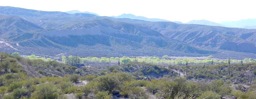
THE SAN PEDRO RIVER VALLEY

Readers note: for those concerned about the prospect of an I-10 Highway Bypass through the valley, see these links:

I-10 bypass Information (Cascabel Working group)

sanpedrorivervalley.org

Daniel Baker Report to ADOT Sep. 21, 2007

Above: San pedro River gallery forest, viewed from lower Soza Mesa near Cascabel. Cottonwoods and willows are just leafing out in March 2003 (in the foreground, paloverde- and creosotebush-covered hills).

Below: the flooding San Pedro River at Cascabel, Arizona in August 2005.

What follows on these pages takes two directions: the first provides a visual tour of the Valley from south to north, while the second discusses ecoregion definitions and issues for our area.

(1) The following link provides a visual tour of the river and associated land forms, with text commentary, focusing mainly on our area and including views of some major tributary washes:

An introductory tour of the San Pedro Valley

(2) Ecoregions or Biomes in Our Area:

The San Pedro River begins in Mexico (not far from the city of Cananea in northern Sonora) and ends at its confluence with the Gila River near Winkelman, Arizona. Its southerly, upstream portion is by far the best known to outsiders, by virtue of its proximity to the burgeoning city of Sierra Vista, Arizona and the major military complex at Fort Huachuca, and the recent designation of a large strip of the watershed there as the San Pedro Riparian National Conservation Area by the U.S. Congress in 1988. Our area, near Cascabel, Arizona, is well downstream from this complex, but The U.S.D.A. (Department of Agriculture) and E.P.A. (Environmental Protection Agency) include a significant part of our area in what they call the "Upper San Pedro Watershed" (click on that link for more information), a designation suggesting our interconnectedness with parts furthe upstream. In the following account we will try to place our area in the wider ecological and historical contexts of this major Watershed. (For map references, see the previous link, or our own San Pedro River Maps.)

See the following website for an excellent introduction to the various dimensions of our river system:

http://www.nature.org/initiatives/freshwater/work/sanpedroriver.htmlhttp://www.nature.org/initiatives/freshwater/work/sanpedroriver.html

Ecoregions or Biomes distinguished by the World Wildlife Fund (see this link) for our area include the Sonoran Desert (our area and toward the north and west), the Chihuahuan Desert (our area and toward the south and east), and the Arizona Mountains Forests (our "Sky Islands") . All three of these zones are characterized by very high degrees of biodiversity, and our Saguaro Juniper lands stand at a crossroads of the three. Indeed, our situation is more complex than this -- our status as a crossroads is reflected in the fact that definitions, interpretations, and boundaries of these ecoregions, and their subdivisions for our area, remain at issue. The Nature Conservancy, for example, distinguishes the Apache Highlands rather than the Chihuahuan Desert as an eastern/southern boundary to the Sonoran Desert -- see that link. And several major authorities disagree about the classification of these biomes. Here we consider some of these problems in relation to our area in the materials indicated below:

  • For more detailed accounts of our area's relationship to "Ecoregions" or "Biomes" (and the differences between various authorities), see the following link:

Ecoregions or Biomes, and our area

  • For an introduction to the major vegetation forms of The San Pedro Valley, both now and in deep time perspective, see

San Pedro Valley Flora: Today

San Pedro Valley Flora: in the Pleistocene

  • For studies of changes in our area's vegetation from the mid-19th century to 1960, see

Changing Vegetation patterns -- Recent

Cienegas

  • For information about and images of our Hot Springs Canyon corridor of the San Pedro River Drainage, including conservation proposals for the corridor, see

The Hot Springs Canyon Landscape

Hot Springs Canyon Corridor Proposal

  • For background on the geology of the San Pedro River Valley, see

Geological History: Walks and Discussions

  • For a bibliography of San Pedro River history, see the following link (and search for "San Pedro"):

San Pedro River History: bibliography

The Udall Center at the University of Arizona provides a series of website pages relating to the San Pedro River Basin, called San Pedro River Basin Projects -- which includes materials from a number of news sources on both sides of the border and covering the following range of topics: water, land use and growth, U.S.-Mexico border issues, science research, and weather and climate change. Click on the link to access this resource.

We will present further description and illustration of the region as time permits.

Back to Information & Images