A Rock Wedge-Building Workshop
Oct. 19, 1996
Sponsor: Redington Natural Resource Conservation District (NRCD)
The U.S. Natural Resources Conservation Service (NRCS) presented a Rock Wedge Workshop in Teran Wash, which was introduced by Redington NRCD Chairman Barbara Clark.
1. The Rationale for Making Rock Wedges, Barbara Clark
2. Relevant Zones of the Teran Wash Watershed, Don Decker
3. Methods and Techniques of Construction, David Matthews
Drawings by Michael Henderson
......................................
Note: Click on the images and drawings below to enlarge them!
1. Barbara Clark outlined the rationale for rock wedge work roughly as follows:

Erosion is very severe in arid lands because too little vegetation is present on the land to break the force of raindrops hitting the ground, on those rare occasions when they do fall. Where land is covered by grasses, forbs (leafy plants), shrubs and trees with litter underneath, raindrops hit these vegetative covers and slide off, landing lightly so they can then be absorbed by the soil. But where land is bare, raindrops hit full force -- at about 30 feet per second -- and spatter the soil. Spattering breaks up clods of dirt into fine particles, which are absorbed by the raindrops, and as this muddy water sinks into the soil, the fine dirt particles contained in it quickly clog soil-infiltration passageways. and consequently the water begins to puddle and then runs off. Clear water percolates into soil ten times faster than does muddy water.
As the muddy water moves over the ground by gravity and links into channels, it gathers speed, and its suspended dirt particles act as sandpaper, so it quickly cuts small trenches that become gullies. Gullies enlarge with every rain, and eventually cut down into the groundwater, draining it and lowering the water table. This becomes a vicious cycle, since whatever shallow-rooted plants are present that depend on ground water will weaken and die. The ground becomes even more barren than it was before, its gullies carry more and more silt, which kills plant and animal life in the streams below as it accelerates through the ecosystem so fast that the water does not so much sustain life as destroy it.
Remedies for this problem are available, but they require a lot of effort and some are too expensive or difficult for most situations. People can provide mulches for barren soil, they can scratch swales across slopes, seed them with drought-resistant plants, and so on. Dams -- whether of earth or concrete or whatever -- can be built in washes to stem the floods. But this is an expensive and laborious task, and unless they are quite large and sturdy, dams are likely to blow out in arid drainages, which are largely carved by occasional but very destructive floods.
In this seminar we consider instead a very simple method, which works best in the upper reaches of desert drainages, where gullies are small, surfaces are rocky, and limited amounts of human labor can make a difference. Rock wedges -- or "Check-dams", which describes exactly what they are intended to do -- can be built by one or two people in a few minutes, and they serve the prime purpose of slowing down the runoff that occurs during and after desert rains. They are not true "dams" in the sense of retaining water after a flood is well past, but are open piles of rock placed in gullies and which merely slow the runoff enough to cause the water to drop some of its silt load, so that eventually terrace-like deposits of silt are formed behind them which retain enough moisture to foster the growth of grasses and other plants in the wash. If these rock wedges are built at close enough intervals, they increase vegetative cover and may even, over time, raise the water table, reversing the destructive process just described above.

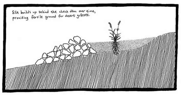
These two diagrams above show in longitudinal cross-section a basic feature of our rock wedge design: for every foot of wedge elevation, provide three feet of wedge-rock downstream from the highest part, and one foot upstream. This counters the tendency for water flow to undermine the structure downstream. (See also below.)
2. Don Decker of the Willcox Field Office of NRCS (below, left) introduced us to the current project,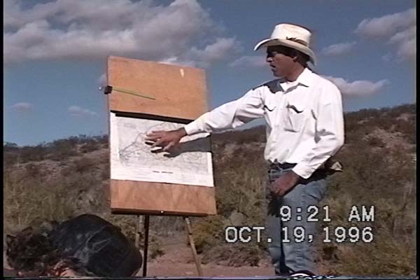 which has selected the Teran Wash Watershed as an area to make long-term experiments testing the effectiveness of rock wedges as a means of range improvement. The map of Teran Watershed (right, below) shows, first, in black outline, the limits of the watershed -- the highest points in elevation -- while the yellow marks the portions of the watershed where both the slope of the washes and the availability of rock raw materials make rock-wedge-building an efficient option. (Click on the map to enlarge it.) As the map shows, the lower portions of the drainage are too large for rock wedges -- they require more extensive, and more expensive structures. The higher washes are too steep -- rock wedges placed there will probably be blown out.
 So we will focus our efforts in the zones marked in yellow (today, in one part of the left-side of the map, near the mouth of the drainage where the light-reflection on the map is evident). The entire drainage has been studied, the NRCS has positioned transect sites across washes in these yellow zones, made lists of species, photographs, etc., so we will be able to test whether these areas improve over time following rock-wedge construction in these locations.
3. David Matthews, Liaison District Conservationist for Zone Eight of the NRCS, (center, below) led the active part of the seminar:
 What we want to do is slow the erosion coming down these hills, trap some sediment in these mostly shallow, limey soils so we can get some vegetation started. It will then help slow the water down, reduce the amount of flooding. We would hope to see the water come off these hills in two or three months rather than two or three hours, as it does now. We will try to "stair-step" the water down.
We try to build these structures in such a way that they won't blow out with the next rain. Instead, we hope to see them here for thirty, forty years. Loose rock is good for this aim. So what we do is try to put these on small watersheds, less than 200 acres. If you're dealing with more volume than that, likely there will be so much water with occasional flash floods that it will blow out any loose rock structures. This whole drainage (Teran Wash) is about 11,000 acres -- obviously you wouldn't build loose rock structures down here in the main wash! So we go as high up in each drainage and sub-drainage as we can, where the amount of water that will run in each small wash is manageable.
You need to put planning into building these things. You look at what materials are available -- keep things low-cost. Here, we look for rock, we look at the existing soils, and we look at the steepness of slopes. Where slopes are very steep, flowing water has high kinetic energy and thus too much force, so wedges should be built only as high on a watershed as we can find gradual slopes.

Keep them small and fairly close together: the farther apart (for a given size), the greater the potential for failure, so keep them as close together as possible. Aim at something 3 or 4 people can build in 10 minutes. The lower in height you build them, the closer together they have to be. The lower the slope, the farther apart you can build them. Slope percentage tells you how far apart to build: 10 % slope is 10 feet rise for every 100 feet you walk. We don't usually build them at a steeper than 15% slope, because as slope steepens you have to build them closer together, and when slope gets really steep the wedges probably won't last in any case. You can measure a slope by having one person pace away from you, sighting on a level at how much higher the person is than you -- 30 paces, and 3 feet higher, means a 10% slope.
Soils are also important. Deep alluvial soils like those in the San Pedro Valley are very erosive, and where soils are deeper you have to build more structures. Here, the bedrock is almost on the surface. So here we must key in the structure as best we can, dig into the soil at the base and around the edges so the water won't wash it out at the side. We look for large rocks: try to have 50% of the rock about 9 inches in diameter. If the rocks are really small, you will need wire (heavier wire is better than chicken wire, which will erode pretty fast) to make a gabion to hold small rocks in place. As you place the rocks into the wedge, try to fit them together so they will hold fast when jostled by running water, and bear in mind the 3:1 ratio of rocks downstream and 1:1 upstream (see diagrams one and two above).
The wedge should be made somewhat lower in the middle than at the sides, so that water will not build up so much that it begins to flow around the sides (thus weakening the soil at the edges, eventually undermining the structure):

So: we look for obvious spots, where it will be easy to build a structure.
 Here, at left, (water flow is from lower right toward upper left), we have two big rocks already present on the sides of the small gulley, which can help key the structure in. We clear the spot out, then dig out across the base in order to "key in" the rocks which will be emplaced along the bottom of the wedge. (If there were no side rocks, this portion would be dug out as well.
 Then we start building the core of the wedge. We try to put the bigger rocks across the base core of the structure; put the flat side down if you can, so it won't rock and roll. Keep it lower in the center than at the sides -- we don't want to divert water around, where it will just erode at the sides.

Try to fit your rocks together as you go -- don't just drop them where they fall. The tighter the fit among the rocks, the better.
 Here the wedge is taking shape, with the larger array of wedging on the downstream side (to the left). You can see we have built up the front side at about a 45 degree angle -- that is, if we go up one foot vertically at the core, we build a rock wedge upstream for one foot (a 1:1 ratio). Downstream is different: we want to go out 3:1, that is for one foot high we build the wedge out 3 feet. The reason for this is that water flow through the wedge tends to undermine the downstream part of the structure most quickly.

We want to give the structure sort of a ramp shape, so the water will flow over and down it smoothly. Here you can see the shape of it clearly (as in the first diagram, above).
The following are some examples of wedges built on Saguaro Juniper lands after the seminar (specifically, in various parts of the Notch Basin):
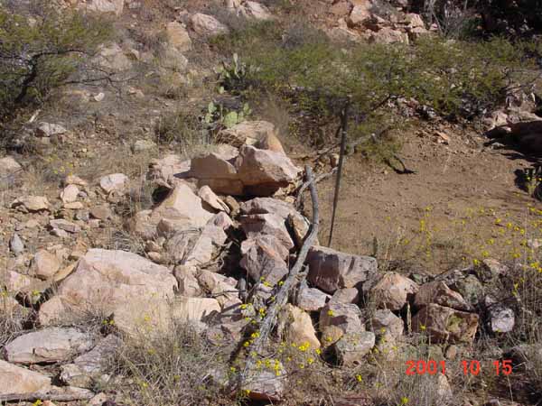
 Here, water flow is from upper right to lower left. This wedge was built high up in this small drainage, just at the head of a large bedrock outcrop (dark gray) in the Notch Basin, below which the slope drops sharply. The wedge has already built up substantial silt and grasses behind it. (In this and the photo below, a walking stick is placed upright in the center of the wedge for scale.)
 Here, water flow is from upper left to lower right, again high in a small drainage and at a point just below which the slope drops sharply. This is a small wedge, with most of the rock on the downstream side.
 Here, water flow is from right to left. This large wedge located right above the Notch waterfall takes advantage of some big rocks which have fallen down from the Notch walls, and sits at the end of a long, slow run. It is building up a substantial silt bed behind it.
 The wedge on the right is photographed from well above it on a fairly steep slope, water flow is from lower right toward upper left. A large silt bed with plants growing up in it has formed in a period of several years, nearly obscuring most of the upstream part of the wedge. It's becoming a terrace.
Back to Building Rock Wedges & Gabions