 ..
..
Building a Rock Wedge/Weir at Lower Cottonwood Seep
The crude "map" below is oriented very roughly with left to the West and North at the top. At the right the wash flow comes from the Waterfall, some 200 yards upstream. Where it has flowed over very hard rhyolite rock above and below the Waterfall, it now runs over a stretch of pale gray "ashflow" rock(?). See also the bottom of the page to be found on this link: Cottonwood Seeps Basin and Wash.
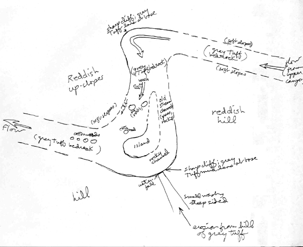
This diagram (drawn early in 1997 to outline the project) shows the geological basis of the Lower Cottonwood Seep: the gray ashflow rock which is labelled "grey tuff bedrock" on the diagram. We got the idea that we might be able to increase the infiltration of wash floods if we could divert the flow into the old side wash on the right, which had become bypassed by the cut that developed into the left side of the wash. This old streambed, full of rocks and grasses, runs around an island through a channel that becomes very silt-ridden below the point of the waterfall at the lower right corner of the diagram. Diversion of the flow would cause much slower runoff and more infiltration at the base of the island. So we decided to build our largest rock wedge to date, using as anchors the two very large rocks already located right in the middle of the cut.
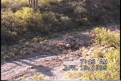
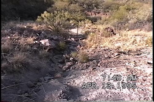
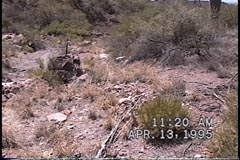
[Note: the first phases of this work were done in 1997. The labeling of some of the stills shown below as "1995" was due to an erroneous setting on the video camera that was not noticed, and hence not repaired, for a while. In 1995 most of us had not even seen the Lower Cottonwood Seep.]
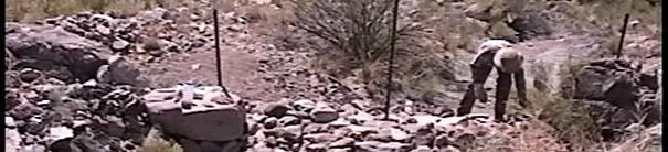
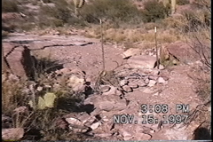
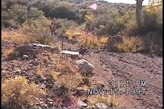
In the photograph below left, the cottonwoods of LCS stand out against an otherwise drab November background (looking south). In the middle, the gray ash-lens that diverts the wash flow to the south is visible at the center of the photo, and on the right is the site of the planned rock weir (with the older stream channel above the more recent cut in the central part of the photo).
 ..
.. ..
..
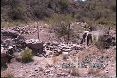
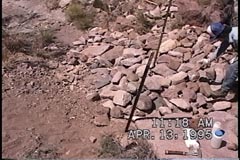
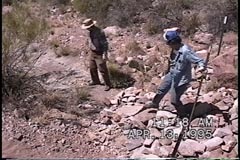
In the photograph below, in April of 1997 the viewer is standing in the wash cut looking downstream toward the main boundary rocks of the gabion, with the first T-post standing in the middle. Some rocks collected for building the wedge are lying along the cut. The Island begins at the left and curves around to the right at the upper middle of the picture. The gray ash-lens can be seen in the foreground and also mid-distance in the upper-center.
Below left, looking downstream, the right bank of the wash with its big anchor rock. The cottonwoods are out of sight to the right. In the middle, the first T-post is being dug into the center of the cut between the two big anchor rocks. At the right, the wedge now fills the gap, and the three T-posts are in place as Tom Orum puts some additional rocks along the edge.
 ..
.. ..
..
At left below, the long downstream pile of the wedge. Nancy Ferguson puts a last rock along the upstream face. In the middle, Nancy walks over the pile toward the downstream side. On the right, a white cord has been tied around the middle of the central T-post (which bisects the photograph vertically). (It is not obvious in the photo, but look carefully and you will see it.) This indicates the level which we calculate the wedge/weir must reach in order to make floodwater divert into the older side-channel. So what we had accomplished at this point was just a very substantial beginning.
 ..
.. ..
..
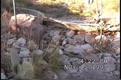
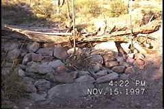
In November of 1997, Arni Sveinnson and Dick Henderson returned after the Monsoon season to see how the wedge had worked. We were at first a bit shocked to see the wedge looking a bit washed out:
 ..
..
On the Left you can see some loose rocks on the downstream side. But as we looked more closely, we could see that what had happened was mainly that so much silt had been deposited in the flooding that it had completely covered the wedge. Note the silt now stretching upsteam from the wedge in the Left photo, and on the Right, the complete covering of the ash-flow bedrock above the weir by the rhyolite silt from upstream.
So we proceeded to reinforce the wedge very substantially, converting it now into a wedge-weir in order to substantially raise the level of resistance to the flow of the wash:
 ..
..
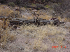
Both of these photos are taken from downstream. The rock-wedge base has been considerably bolstered (with some very large rocks brought in by Arni), and in addition we placed Saguaro ribs and other brush materials on top and tied them into place with rope.
We returned and further bolstered the wedge-weir in the summer of 1998,adding more saguaro ribs, also strengthening the edges of the structure, and building supplementary wedges along the side wash, but then the tasks of rebuilding the Water Tanks intervened, followed by efforts to reinforce these tanks with bentonite (see the link: Water Tanks and Springs). The consequence was that we did not return to the Lower Cotton Seep wedge/weir until very recently, on March 7, 2002. We were quite surprised and pleased to see what had happened in the wash during that interval:
 ..
.. ..
..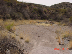
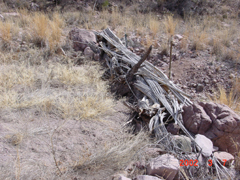
These are quite remarkable results: on the Left, the view is taken from the right bank looking across the weir, whose saguaro ribs remain entirely in place and a full load of silt has formed behind them to the left. In the Middle, from upstream, one can see the array of grasses forming in this upstream silt. On the Right, taken from much further upstream, you can see the extent of the more reddish, rhyolite-based silt deposit that has formed above the weir, entirely covering the ash-flow bedrock (which is visible only at the very bottom of the photo). We have built a very large silt-trap here in the middle of this wash.
There is more work to do -- and we will report more on this before the summer. But at this point this project has to be considered a very substantial success. We are particularly pleased with the effectiveness of the saguaro-weir part of the structure, which considerably heightens the level of flood runoff control.
Back to Information & Images