The "Bullock Fire" on the Catalinas:
Images from Cascabel, Arizona
on May 26 & 27, 2002
For maps showing progressive extents of the Bullock Fire, see this link
All of the photos below were taken from the Canyon Road above Cascabel, near Lynn and Miller's Air Strip. The first three were taken yesterday, May 26, at about sunset. The main smoke is coming from beyond the dark blue ridge paralleling the dark foreground slope in the lower left quadrant of the first image. This ridge lies above Redington Pass. The second photo at lower left provides a closeup.

 ..
..
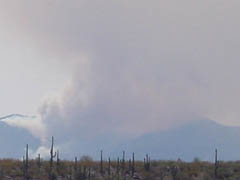
The two photos below were taken today (Monday May 27), at about 2 pm. The plume of the fire is a great deal larger, and in full daylight you can see a glow at the base of the plume. (The ridge above Redington Pass, visible in the previous photos, is also visible here.) The second picture provides a closeup of the glowing base of the plume.

Below, using the greater digital zoom of the video camera, a closeup of the ridge of the Catalinas running down from Guthrie Mountain, and to the right below, a closeup of the fire center beyond the ridge.
 ..
..