An Ancient Native American Trail in the Cascabel Basin
Source: Dobyns, Henry F., 1981, From Fire to Flood: Historic Human Destruction of Sonoran Desert Riverine Oases, Socorro, NM: Ballena Press, p. 15-19.
On May 23, 1830, under orders from the Commandant General of Sonora and Sinaloa, Captain Antonio Comaduran led a military expedition out from the Spanish Royal Garrison at Tucson to conduct an offensive campaign against enemy Apaches whose heartlands were located well to the northeast, around the flanks of the Gila River. The initial troop of about 100 men included both infantry and cavalry, as well as a number of Pima Indian guides, and set out toward the east by way of what is now called Cienega Creek. On May 25 after a meeting at the Tres Alamos ford of the San Pedro River, near its confluence with today’s Tres Alamos Wash, some 50 "peaceful Apaches" agreed to accompany the troop on its campaign. From there, at 3 p.m. the war party marched north along the west bank of the river, then crossed at the Bado Pedragozo (Rocky Ford) at 6 p.m., where they camped for the night.
The May 26 entry in Captain Comaduran’s Journal then reads as follows: “At 4 o’clock in the morning I dispatched the infantry in charge of Militia Captain Don Ygnacio Ortiz to reconnoitre Agua Caliente [Hot Springs] Canyon. At daybreak, I began to march with the cavalry toward the north, leaving the river route, traveling toward the Sierra de Santa Teresa. Comaduran did not distinguish the Galiuros or Winchesters as distinct mountain ranges at this time. At 10 o’clock I arrived at the Hot Springs Canyon, where the infantry awaited me. Having learned that the reconnaissance it carried out found nothing of note, I ordered a halt because there was no water ahead. Around 4 in the afternoon I continued the march in the same direction, and around 9 at night I halted at the Hot Springs Pass. There I slept, and awakened after an uneventful night. [ibid., p. 20]
May 27. At daybreak I commenced the march toward the north, and about midday I arrived at Black Canyon, where I halted. I dispatched 16 infantrymen to scout the Water of the Dead in Arivaipa Valley, with orders to wait for me there if they found nothing. At 5 in the afternoon I continued the march in the same direction. At 7 that night I arrived at said water where the 16 infantrymen awaited me without having discerned anything noteworthy.” [Ibid.]
........................................................
In footnote 12 of his text, Dobyns suggests that Water of the Dead was a Spanish translation of a Northern Piman term, referring to a water source in what had been the eastern frontier of Northern Piman territory in aboriginal times, now abandoned (and the name perhaps connoting ancestors). Elsewhere Dobyns (1976, Spanish Colonial Tucson: A Demographic History, Tucson: University of Arizona Press, p. 21) describes how the easternmost settlements of the Northern Pimans (people called AImuris and Atauuaukwani), located along the San Pedro River and its Arivaipa Creek tributary, were forcibly relocated westward to the Santa Cruz Valley by the Spanish colonial military authorities in 1762, ostensibly to consolidate defenses again the Apaches. (Finding “anything noteworthy”, as Comaduran puts it in the cited passage, refers to seeing evidence of recent Apache presence in the area.)
Henry Dobyns, who uses Comaduran’s Journal as a major source for his 1981 book, observes of the Bado Pedragozo reference that the Captain’s Native American scouts led him along a very old trail that became well established during remote pre-Columbian times, citing the great historical geographer Carl Sauer, who wrote that Francisco Coronado himself took this route; “an old Indian trail to the Hopi country... still remembered as leaving for the north about... [Cascabel]... swinging over and around the Galiuro Mountains to the Aravaipa basin and to the Gila above San Carlos, a route which is very direct, and is well supplied with grass and water.”
[Ibid., ftnt. 10, p. 19.]
Here Dobyns quotes from Sauer's 1932 book, The Road to Cibola (Ibero-Americana 3, University of California, p. 36). There, according to Sauer's reconstruction, Native American guides led Coronado’s massive expedition (including several hundred horses) along this route (which was well-suited for both foot travel and horses) heading toward Zuniland in 1540 C.E.
On the other hand, Herbert Bolton, the most renown historian of the expedition, believed that Coronado’s route went eastward at about Tres Alamos, then north along the Sulphur Springs Valley [1949, Coronado: Knight of Pueblos and Plains, Whittlesley House and Univ. of New Mexico Press, pp. 105-6.]. But Sauer -- who gained wide renown as a geographer as much as an historian and who also directly sampled the archeology of the San Pedro in this area -- had more intimate knowledge of the San Pedro Valley than did the somewhat later historian.
So we are confronted here with both a very probable trailway of pre-conquest times and a possible one of the first agent of the Spanish conquest in this area. In the discussion that follows, thanks are due to TOPO! for the maps:
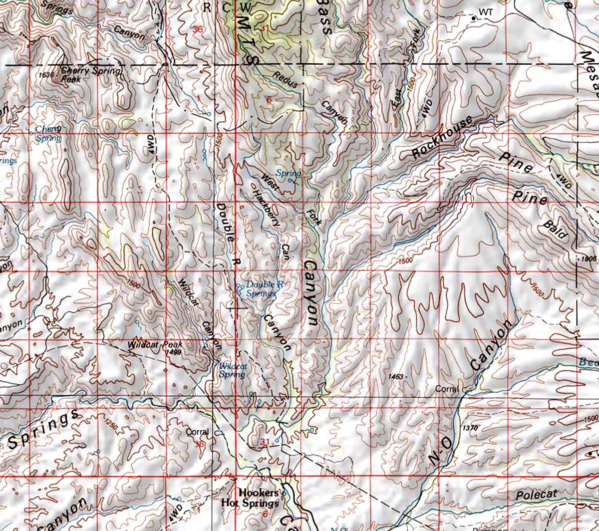
If we look at the contemporary map at left, Hot Springs Canyon runs permanent water at its confluence with Bass Canyon, suggesting this as the likely location where the infantry awaited him. The actual hot springs are a short distance upstream from this location, at "Hooker's Hot Springs".
Click on the image to enlarge it.
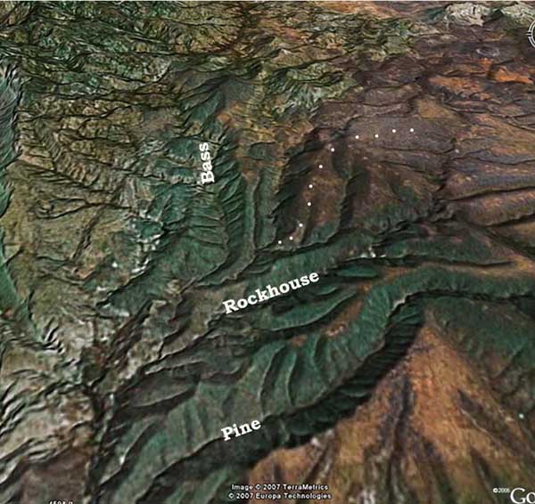
The "Hot Springs Pass" where Comaduran camped would seem to refer to the area of the saddle between the Galiuros and the Winchesters now called "The Mesas"; this is located at the far upper-right corner of this map.The Bass Canyon tributary Rockhouse Canyon runs down from The Mesas.
Black Canyon on the east slope of the Galiuros lies directly north from there, beyond the north end of the map at left, which shows the drainage leading into the Aravaipa basin.
From The Mesas into this area is a flat, fairly open and direct route, linked today by substantial local roads.
Click on the image to enlarge it.
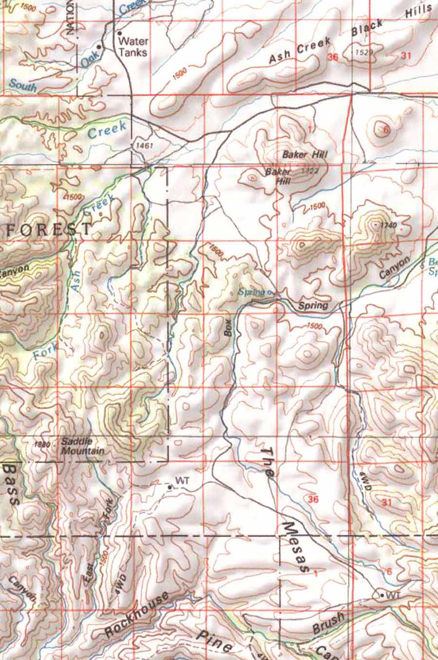
Note that a contemporary 4-wheel-drive road leads from a watertank (marked "WT") in the lower left quadrant of the map down the ridge east of the East Fork of Bass Canyon. This route may well mark the ancient trail where it rose out of the Hot Springs Canyon drainage.
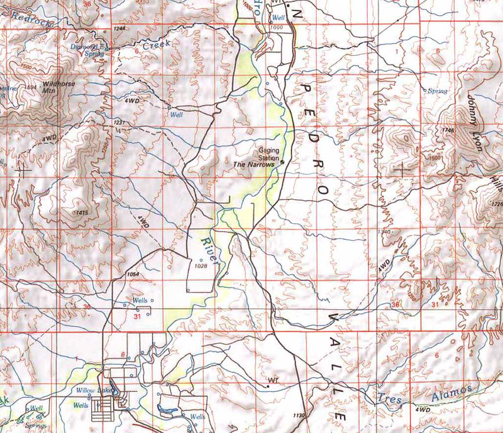
One pivotal question in tracing this route concerns the location of the Rocky Ford (Bado Pedragozo) mentioned by Comaduran. Consulting the map at left, the location of the Tres Alamos ford lies at the lower left corner of the image (where the contemporary residential subdivision is demarcated). The Benson Narrows, located west of the Johnny Lyon Hills (where the Middle San Pedro basin geo-technically begins) in the center of this map, might seem a likely location, but this is only about 5 straight miles north of the Tres Alamos Wash confluence, hardly a three-hour march, and moreover along this portion of the river today there is no fordable area when the river is running (as it did continuously in the nineteen century and earlier times, see Middle San Pedro Cienegas). Today the next location providing a satisfactory ford for either vehicles or animals lies well further north.
The confluence of the San Pedro River with Kelsey Wash, located about 12 straight miles north of Tres Alamos as shown in the map at left, is the sole current crossing that works when the water flows.
Click on the image to enlarge it.
When told of the Rocky Ford reference in Comaduran's account, Jim Corbett, a late local rancher of unusual perspicacity (see that link), suggested looking for a place where a large side-wash regularly brings large-rock debris down into the main stream (thus producing more solid ground for a crossing than the generally muddy river bottom), and Kelsey Wash nicely fits this profile.
Of course, we cannot assume that the lay of the riverbed today is identical with what it was in 1830 (much less, 1540!), but today, the nearest road crossing of the San Pedro Wash, at a place having a firm gravelly bottom, lies roughly opposite the mouth of Kelsey Wash (which is well-known by locals to be very dangerous in flash floods, carrying big loads of rock debris down to the confluence), and the basic location of this wash has not changed in recent geological times.
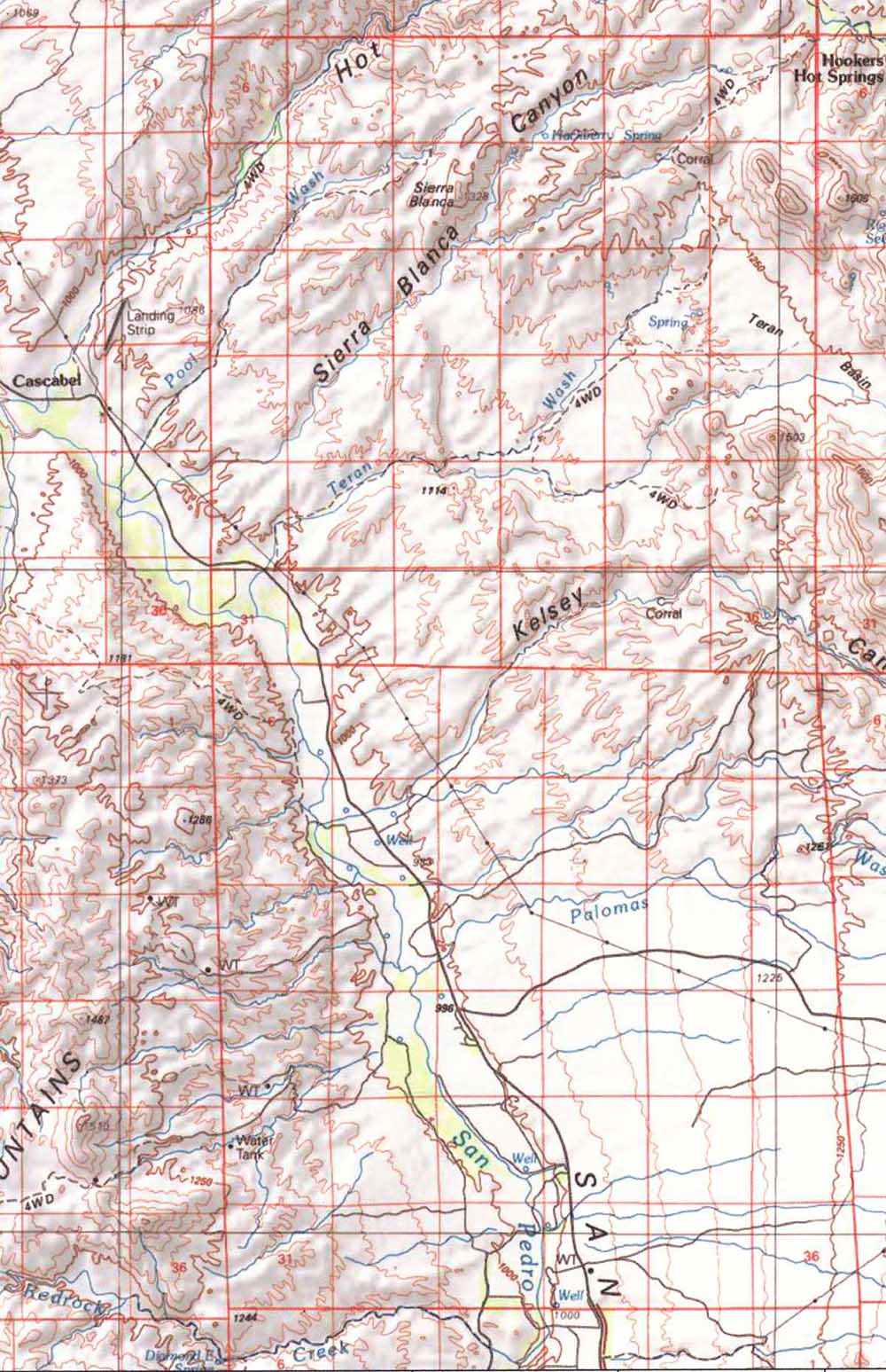
If Comaduran’s (and, perhaps, much earlier Coronado’s) party did cross the river at Kelsey Wash, then a directly northerly course would have led them to the vicinity of Teran Wash and perhaps into the Teran Basin (visible in the map above at middle-right in the upper-right quadrant of the image). Alternatively, the route might have led to the area around Sierra Blanca in the vicinity of our Saguaro Juniper lands.
While we may never know the actual routes, the possibility that Saguaro Juniper lands may have been trodden by Coronado’s expedition is intriguing. As we walk our lands, we might well follow the suggestions of Tom Orum’s friend, Barney Burns, an anthropologist familiar with archaeological problems of the Southwest, who says that Coronado’s party, with its very large contingent of horses, would surely have left some horse shoes lying along their way, and though more than 550 years have passed the rust-remnants of these might still be recognizable if exposed. Their distinctive feature was rectangular nail-holes in the shoe.
In any case, returning to the locations indicated by the topmost map above, it would seem fruitful to look closely along the route traced by the 4-wheel-drive road indicated there, and thence northward toward Black Canyon. Here below is a view made available thanks to Google Earth:
Author's Note: Since I first wrote this article in 2001, the Center For Desert Archaeology (CDARC) has raised the issue of Coronado's route and the likely evidence for it, notified people living in the potential routelands to participate in considering the question, and published further research on the subject. This makes the discussion we provide here of that historical aspect somewhat out of date, though the matter of the ancient Native American trail remains relevant in any case. When time permits, we will update the essay incorporating CDARC's work. [Dick Henderson]
.....................................