Earlham/Saguaro Juniper Saguaro Study
Progress Report (March 26, 2006)
Nancy Ferguson and Tom Orum[1]
Introduction. Part of the Preamble of the Saguaro Juniper covenant[2] describes a community of people seeking to better understand a specific land community. In this project, the Earlham Southwest Field Studies community joins the Saguaro Juniper community in learning about a particular saguaro population in Hot Springs Canyon.
Background. A major goal of Saguaro Juniper is to get to know the land and the plants and animals that live here. This saguaro project is part of that on-going effort. The saguaro (Carnegiea gigantea) is a flagship species for the Sonoran Desert and the Saguaro Juniper land is on the northeastern edge of the Sonoran Desert. This study collects the same types of data as another project Tom and Nancy are working on in which the saguaro population in six ten-acre plots in Saguaro National Park have been censused every year since 1942. Collecting the data in the same way here allows comparisons of saguaro populations in two different settings.
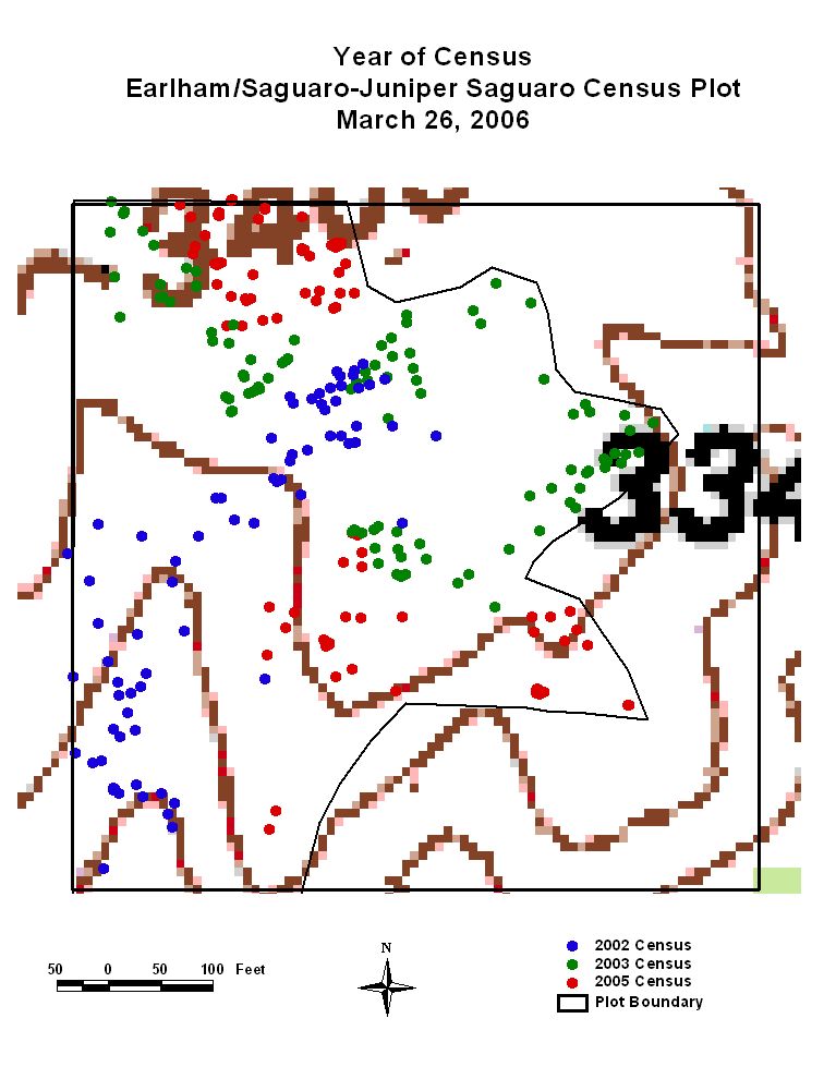
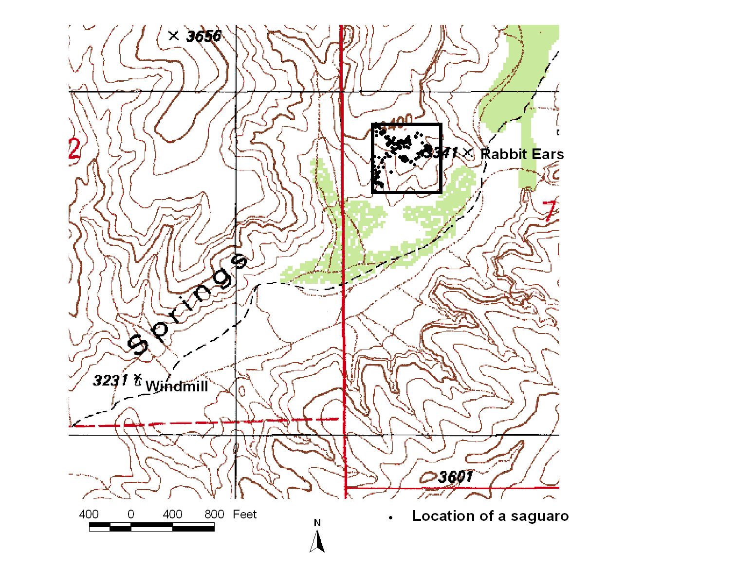
Earlham Southwest Field Studies students have mapped and described saguaros in the Hot Springs Canyon Plot in 2002, 2003 and 2005. So far 268,000 square feet have been mapped covering 62% of the 10-acre plot.
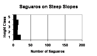
1) There are more saguaros in the Earlham/Saguaro Juniper plot than in any one of the six plots in Saguaro National Park.
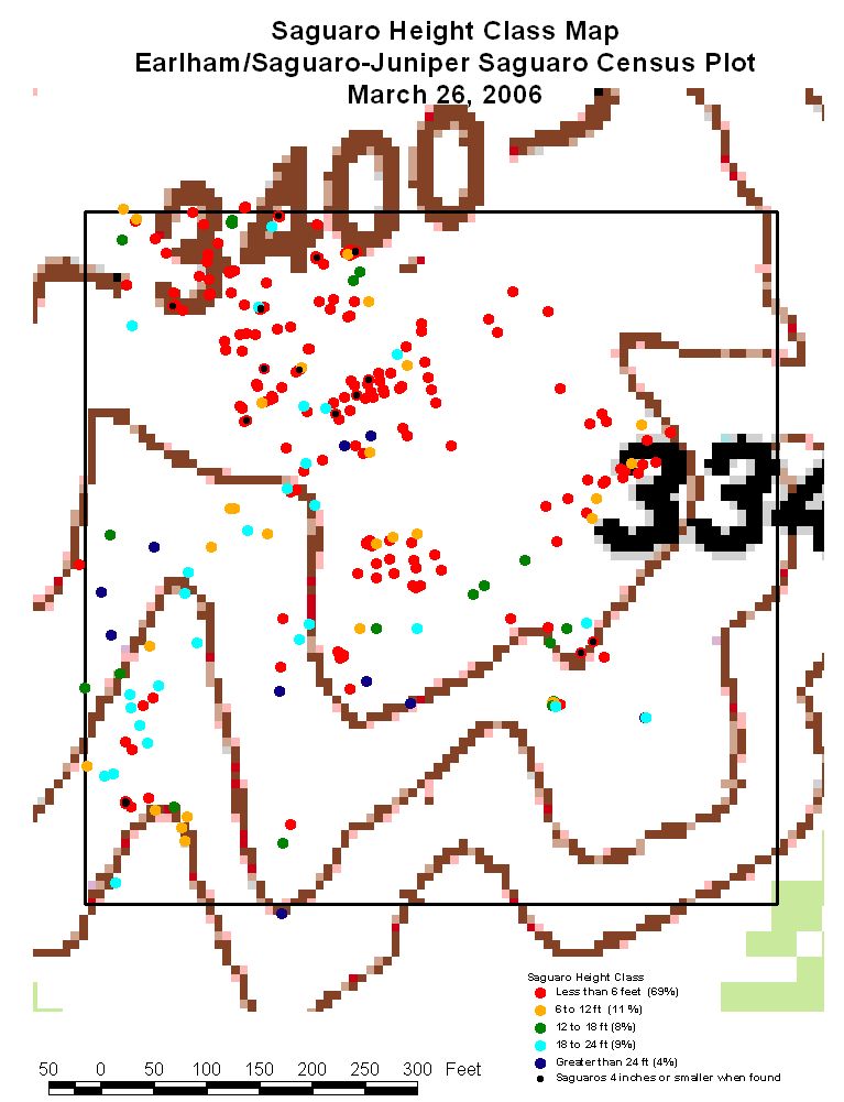
2) The height/age structure[3] of the saguaro population[4] in the Earlham/Saguaro Juniper plot is similar to the height/age structure of the six plots in Saguaro National Park. In both locations about 70% of the plants are less than 6 feet tall and are too young to produce seeds.
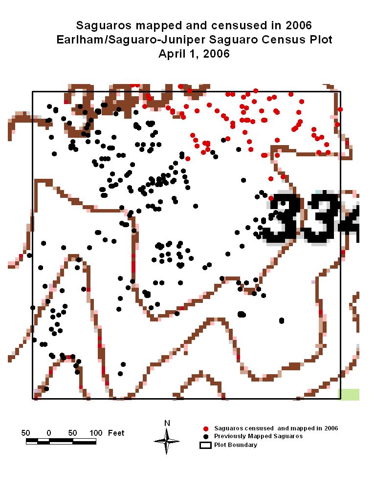
3) There is a new cohort[5] of saguaros in the Earlham/Saguaro Juniper plot that has not been found in Saguaro National Park. From this we surmise that there was a germination and survival event in Hot Springs Canyon that did not occur in the Park.
4) The gently sloping part of the Earlham/Saguaro Juniper plot has a different height/age structure than the steeply sloping part.
Footnotes
1. Nancy is a retired wildlife biologist and Tom is a retired plant pathologist. Both retired from the University of Arizona. Our address is 2018 W. Los Reales Road, Tucson, AZ 85746. Phone: 520-573-1679. E-mail addresses: ferguson@u.arizona.edu and torum@mindspring.com .
3. height/age structure: Age structure is the relative proportion of individuals in each age group of a population (www.emc.maricopa.edu/faculty/farabee/biobk/BioBookpopecol.html viewed 1 April 2012). In saguaro research, we seldom know the actual age of an individual saguaro. The height of the individual is used to estimate the saguaro’s age. (Hastings, J.R. and S.M. Alcorn. 1961. Physical Determinations of Growth and Age in the Giant Cactus. Journal of the Arizona Academy of Science 2(1): 32-39.)
4. population: A collection of organisms of a particular species living in a given geographic area or space (www.en.wikipedia.org/wiki/population viewed 1 April 2012).
5. cohort: A group of individuals born at the same time or within a short interval of time. (Akcakaya, H. Resit; Mark A. Burgman; and Lev R. Ginzburg. 1999. Applied Population Ecology: Principles and Computer Exercises. Second Edition. Sinauer Associates, Inc., Publishers, Sunderland, Massachusetts. 285 pp.)
1. Dimmit, M.A. 2000. Cactaceae (cactus family). P. 184-193 In: Phillips, S.J. and P.W. Comus, eds., A Natural History of the Sonoran Desert. Arizona-Sonora Desert Museum Press, Tucson and University of California Press, Berkeley. 628 pp.
2. Fleming, T.H. and A. Valiente-Banuet, eds., 2002. Columnar Cacti and Their Mutualists: Evolution, Ecology, and Conservation. The University of Arizona Press, Tucson. 371 pp.
3. Hazen-Hammond, S. 1997. The Great Saguaro Book. Ten Speed Press, Berkeley, CA 144 pp.
4. Humphreys, A. and S. Lowell. 2002. Saguaro: the desert giant. Rio Nuevo Press, Tucson, AZ. 59 pp.
5. Steenbergh, W.F. and C.H. Lowe. 1977. Ecology of the Saguaro: II Reproduction, Germination, Establishment, Growth and Survival of the Young Plant. National Park Service, Scientific Monograph Series: number 8. 242 pp.
Overview Map of the 10-acre Earlham/Saguaro Juniper Census Plot
in Hot Springs Canyon West of the Rabbit Ears Saguaro Hill
Comparison of Earlham/Saguaro Juniper Census Results with the Densest
of the Six Plots in the Saguaro National Park Rincon Mount District Census
Hot Springs Canyon Earlham Plot Saguaro National Park Plot F-5
(approximately 7 acres censused thus far) Plot size 10 acres.
height Class Number of Saguaros height Class Number of Saguaros
in the height Class in the height Class
0 to 6 ft 195 (69%) 0 to 6 ft 172 (71%)
6 to 12 ft 30 ( 11%) 6 to 12 ft 35 (14%)
12 to 18 ft 22 ( 8%) 12 to 18 ft 12 ( 5%)
18 to 24 ft 27 ( 9%) 18 to 24 ft 12 ( 5%)
24 ft and more 11 ( 4%) 24 ft and more 11 ( 5%)
Total 285 Total 242
Earlham/Saguaro Juniper Census Field Instructions March 26, 2006
Work Guidelines.
#1. Work Slowly. This is not a race. Some of the area we will be covering is steep. If you are not comfortable going to a particular location, do not go. If a saguaro is too difficult to reach, make an estimate of distance and note that it is an estimate.
#2. Watch where you step and reach. There are plenty of sharp and pointy things in the desert. Keep an eye out for snakes. Look before you put your foot or hand down.
#3. Drink lots of water.
Teams.
After hiking to the plot, we will divide into two teams. The teams will begin where we left off in 2005. Job descriptions for the team members are given below and printed on 3 by 5 cards for distribution and reference in the field.
Jobs.
Compass. Stand at a known (already mapped) saguaro and use the compass to measure the direction to the new saguaro. Report findings to the distance and direction recorder using the pattern in the following example:
118 degrees from plant A4 to plant A5.
(Note: 0 degrees is North; 90 degrees is East; 180 degrees is South; and 270 degrees is West.)
The compass task includes holding the beginning of the tape at known plant for measurement to be made to new plant.
Tape measure – end/ and Carpenter’s rule. Unroll the tape measure from the known plant to the new plant. Report distance to “distance and direction recorder” round off to the nearest 6 inches.
Also report aspect (compass direction in which water would run) and a rough estimate of slope to “describer”. Estimate slope as “very steep”, “steep”, “pretty steep”, “not too steep”, and “gentle”.
With carpenter’s rule, measure all saguaros less than 6 feet tall to the nearest ¼ inch. Report results to the “describer”.
Distance and Direction Recorder. On the data form provided record the distance and direction from the known plant to the new plant. Be sure the compass person reports the data from the known plant to the new plant according to the following example:
15 ft at 118 degrees from plant A4 to plant A5.
Describer.
On data form, describe the saguaro being mapped. Give height estimate to
nearest height class: Class I: less than 6 ft; Class 2: 6 to 12 feet; Class
Map Maker. Using the map and scale provided, record the approximate location of each plant using the data given to the “distance and direction recorder” by the compass person and the tape measure person. Double check that the readings “make sense” in terms of how the points look on the map. Notify distance and direction recorder if something looks wrong. Label each point with the plant id.